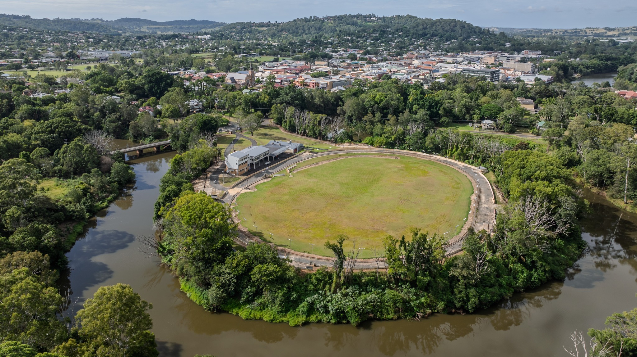
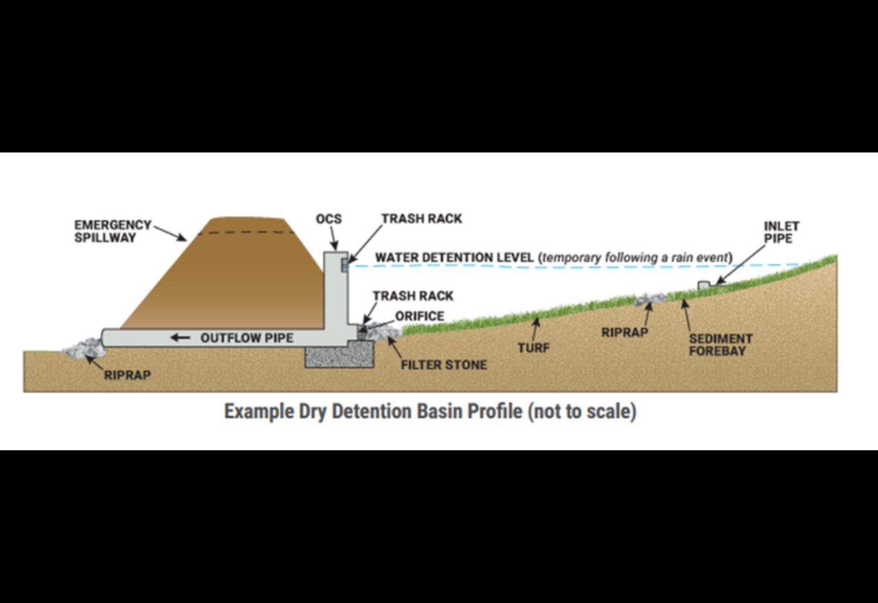
The Lismore App
The Lismore App
Your local digital newspaper
Games/PuzzlesBecome a SupporterFlood RecoveryPodcasts
The Lismore App

Local


Access to essential medicines during Ex-Tropical Cyclone Alfred

08 March 2025, 5:37 AM

People impacted by Ex-Tropical Cyclone Alfred who require essential medicines, including diabetes, heart and asthma medicines, can access a limited supply without a prescription at pharmacies.                       NSW Health has issued an Authority under the Poisons and Therapeutic Goods legislation that enables pharmacists to supply prescription medicines to people without a prescription who are affected by the cyclone.NSW Health is working with local hospitals, pharmacies and health professionals in the affected areas to ensure the community is supported and essential medicines are available to those who need them.The temporary change is designed to assist people affected by the cyclone by ensuring they can continue to access essential medicines.    While some community pharmacies may be closed in the affected areas, many pharmacies placed advanced orders to ensure they retain adequate stock.NSW Health has also brought extra medicines into the affected region to assist the community.Where able to, people are encouraged to phone ahead and try alternate pharmacies if their usual pharmacy is closed.The full conditions of the supply of prescription medicines by a pharmacist without a prescription are listed in the Authority, published online here.     For more information speak with your local pharmacy, GP; call healthdirect on 1800 022 222; or visit: https://www.health.nsw.gov.au/pharmaceutical/Publications/authority-pharmacists-tc-alfred.pdfMinister for Regional Health Ryan Park, “People who are impacted by the cyclone are strongly encouraged to pack their medications and prescriptions while preparing for its impact and if evacuating.“But in unfolding events like this, they may be lost or suddenly become inaccessible.“If you find yourself in this situation, if you can, please contact Healthdirect on 1800 022 222, or speak to a pharmacist, to seek advice specific to your circumstances.“If your medication is considered essential, pharmacists will be able to provide you with a full pack without a prescription to ensure you don’t run out during this extreme weather event.”President NSW Pharmacy Guild Mario Barone said, "Community pharmacies are ready to support patients across northern NSW.“The continued dispensing authority means that you can get your medicines even if you don't have a script and can't get to your doctor."

Essential Energy and nbn update: 31,000 homes without power

08 March 2025, 5:34 AM

Thanks to a break in the weather today (Saturday, March 8) across parts of the Northern Rivers, Essential Energy crews were able to make some progress towards restoration. As of 4.30pm, there are around 31,000 homes and businesses without power in various communities from Tweeds Heads through to Grafton due to the impacts of ex-cyclone Alfred.An Essential Energy spokesperson said crews were able to safely restore power to around 19,500 properties throughout the day, however, continued extreme weather has resulted in additional outages."There has been a flood watch issued for multiple areas including the regions of Lismore, Dorrigo and Kyogle with significant rainfall forecast over the coming days. Customers are encouraged to prepare to be without power for several days as the extreme weather conditions continue to make it unsafe for crews to work in and cause damage to the network."When the weather clears, additional crews will be brought in to assist with the cleanup and repairs; however, access to locations prone to flooding or landslides will delay restoration in some of the hinterland or more remote areas of the region."If flood waters impact communities, it will lengthen the time before power can be restored. Crews are unable to turn the power on safely if powerlines or areas of the network are in contact with water. "If you need to evacuate for flood purposes, if safe to do so, please turn off all switches and mains before the flood goes through. This includes solar and/or battery systems. "We understand this is a very challenging time for our customers and we thank you for your patience and understanding. The safety of our crews and our communities is paramount."We understand that this is a very challenging time for our customers and we thank you for your patience and understanding. The safety of our crews and our communities is paramount. For information about evacuation centres in your area, please visit the NSW SES website. If you see any of the above or powerlines in water, please stay away and call Essential Energy on 13 20 80 to report the damage. In an emergency always call 000.For up-to-date information on impacted locations and estimated restoration times (when known), visit the Essential Energy website outages page.NBN says 209,000 non services have been affected across South East Queensland and Northern NSW.Across Northern NSW the number of affected services has reduced to about 21,000 across 50 areas, primarily located in the Tweed and Ballina local government areas. For a full list of affected areas and suburbs please see here:  IMPORTANT UPDATES - Cyclone Alfred. An nbn spokesperson said, "Most of the impact is caused by mains power outages. Equipment connected to the nbn network will not work during a power outage. The number of outages will fluctuate as the power situation changes in the impacted areas.  "Approximately 700 of our sites are operating on backup power, supporting around 28,000 services. It is too early to tell if there is any damage to network assets. We have teams ready to go in the impacted areas to assess any damage to commence repairs once it is safe. "Our top priority remains the safety of our team and the broader community."

Lismore CBD on the edge but more positive as Rock Valley man rescued from floodwaters

08 March 2025, 3:32 AM

The key message from NSW Premier Chris Minns at today's media briefing was that this event is not over because Alfred has been downgraded to a low-pressure system and is now referred to as ex-Tropical Cyclone Alfred."It's not over for the following reasons, the rivers are full, the rain is continuing and expected to keep falling in the days ahead, and wind conditions are very high and extreme, particularly on the coast, particularly in the Byron Shire right up to the Queensland border. So for those three reasons, it's crucially important that the public not dismiss this weather event, as something that's already passed."It really doesn't matter to us whether it's been downgraded from a tropical cyclone to a weather event, or whether it's still a tropical cyclone, the effect on the Northern Rivers communities and lower down into the Coffs area is still the same for thousands and thousands of families. That's a really important point. This can't be just trivialised or put to one side. The next 24 hours will be crucially important as we look to see what the weather event will do to these communities."With hundreds of Lismore CBD business owners on edge waiting to see if the levee wall will be overtopped, the Premier said, "Look, it's close. I mean, in all candour, the latest models are, it's right on 10.8 which could be just under, just over, at various parts. We hope that it's under that.(Member for Lismore Janelle Saffin getting a leg-up to see over the levee wall at the Browns Creek Pump Station by Minister for Emergency Services Jihad Dibb earlier today.)"We said from the very beginning, right from the beginning of Cyclone Alfred that we would prepare for the worst and we would hope for the best. And I think if you come through town, for those that aren't in town and watching this on television, there's an enormous amount of resources in town. We're ready. We're ready for the possibility of it overflowing. Obviously, we hope that it doesn't, but it certainly could, and if it does, it's likely to be today."At 2:10pm, the Wilsons River height in Lismore was 9.27 and steady. Other points in the catchment were Goolmanagar Creek 4.07m and steady, Terania Creek at The Channon 5.29m and rising and Coopers Creek at Corndale 8.05m and rising.Earlier today, Rod and Sharon Latimer, the owners of Little Polli & the Blackbird on Magellan Street, were sandbagging just in case the levee was overtopped. Everything in the shop had been removed but if they could the shop from floodwaters then it was worth the effort.NSW SES Acting Superintendent Stuart Fisher said there had been 29 flood rescues across the Northern Rivers over the last two or three days, which included 18 overnight rescues, one involved a man at Rock Valley (18km northwest of Lismore)."The majority of them were very minor to be out there. But we did have one in a place called Rock Valley where a four-wheel drive tried to cross the river system, and got swept off the bridge into the water. New South Wales Police rescue and New South SES responded, and thankfully, that gentleman was saved."But again, as I talked earlier, the complacency is starting to slip in there. We do not want that. People are out having a look at what's happening with the flooded waters. They do not know that it only takes about 30 centimeters of water, if that, to flush you off a bridge or into the river. So again, just be very, very careful. "Acting Supt Fisher also referred to the man washed away in flood waters at Megan, northeast of Dorrigo, near Coffs Harbour."Do not, and we say it time and time and time again, do not drive through flooded waters. You may have a four-wheel drive. You may think you can go through them, but as it showed last night, you can't."Earlier today, the Lismore App observed an SES boat crew making its way to isolated North Lismore people that did not heed the evacuation orders."All our crews are out. We've got community liaison officers out all over up and down the coast. Last night, we went to one gentleman that needed some assistance, and out of our own kitchen took some food to get him through. And then we've referred him on to community services. We'll monitor him, and we'll monitor everybody else, and work with the Evacuation Team and the Emergency Operations Centre. So we are looking at all that, and we are managing."On the lips of the Lismore and Northern Rivers residents who were asked to evacuate on Thursday, is when can they move home? Especially, for thos who ended staying in evacuation accommodation, such as SCU which is currently housing 230 people.Premier Minns said, I can understand if you were subject to an evacuation order and you're staying with family and friends or you're at an evac center, you're probably thinking to yourself, well, when can I go back? I can assure you, as soon as the SES can lift the order, they will."There's been several areas in Port Macquarie that are no longer subject to evacuation orders. The SES monitor it very closely with the BOM. They do it in real time, they don't muck around. We recognise, the government and emergency services recognise, that we want to get families back into their community as soon as possible. But safety is the number one issue here, and with the Wilson either steady or slightly rising, now is not the time to be returning to your house in the Lismore area."So there's very clear, very precise evacuation notices through the SES and on the Hazards Near Me app. We're asking people to stick by that."For those who need medical or mental advice:For 24/7 medical advice call North Coast Health Connect on 1800 198 888For 24/7 mental health support call Medicare Mental Health on 1800 595 212

Woodburn and surrounds asked to evacuate before midday

07 March 2025, 10:05 PM

The NSW SES is directing people in Woodburn and surrounds including all properties between River Street, Uralba Street, Langs Way and the Pacific Motorway to EVACUATE BEFORE 12:00 pm Sat 08 Mar due to moderate to major flooding.You must evacuate before this time because evacuation routes may be cut.Evacuation InformationYou should evacuate to stay with family, friends, or alternate accommodation in areas unaffected by flooding. If you are unable to find accommodation, Evacuation centres have been set up at the Evans Head RSL, 11-13 McDonald Place, Evans Head.If you remain in the area, you may become trapped without power, water, and other essential services. It may be too dangerous for NSW SES to rescue you, and buildings may not be able to withstand the impact of flood water.What are we expecting?Based on the predictions from the Bureau of Meteorology, rainfall associated with Tropical Cyclone Alfred may cause rapid river rises and extensive flooding along NSW coastal rivers.Heavy and locally intense rainfall is forecast from Wednesday into the weekend over Northern NSW. Flash flooding is possible. High tides and large waves are expected to increase the flood risk and impacts in low lying coastal areas.Be advised there is current Watch & Act - Stay indoors warning is in place for the Northern Rivers.This event may change quickly. NSW SES will monitor the situation and update warnings if the situation changes.What you need to do:If you have a Home or Business Emergency Plan, follow it.Gather your possessions for evacuation. These might include mobile phone, charger, battery-powered radio, medicine, rain gear, warm clothes, blankets, baby and pet items, water, food, torch, something to attract attention, and valuables like photos and insurance or banking records.Gather your pet(s) and companion animals for safe travel.Relocate waste containers, chemicals, and poisons well above floor level.The safest option is to evacuate as early as possible to avoid additional hazards. Do not wait until the last minute.Immediately move to a safer location away from present and potential flooding. Travel to the home of family or friends who are in a safe location away from present and potential flooding.If driving conditions are dangerous, safely pull over on higher ground away from trees, drains, low-lying areas, and floodwater. Find alternative travel routes if roads or underpasses are flooded.Be aware of road hazards including mud, debris, and damaged roads or bridges.Avoid storm drains and pipes, ditches, ravines, creeks, and rivers.Never drive, walk, ride through, play or swim in floodwater - it is dangerous, toxic, and may void your car insurance. If it's flooded, forget it. Fines apply.Obey all signs about road closures and instructions from emergency services.People working or camping along the river should monitor river heights and be prepared to relocate to higher ground.Farmers should consider moving livestock and machinery to higher ground that will not become an island.All campers and caravans relocate away from the sites next to water coursesWhen you evacuate register at Register.Find.Reunite https://register.redcross.org.au/ so that your friends, family and emergency services can be informed that you are safe.

More than 39,000 without power and 20,000 have lost NBN

07 March 2025, 9:44 PM

As at 6 o'clock this morning, Essential Energy reported more than 39,000 homes and businesses were without power, with winds bringing down trees and blowing debris into powerlines overnight.An Essential Energy spokesperson said, "The current weather conditions are preventing Essential Energy crews from making repairs at this time; however, teams have undertaken significant preparation work, including moving vehicles to assist access, arranging for fuel pods, logistics and communication tools for crews, readying extra resources from across the state to support when safe to do so and ensuring extra electrical equipment is available and ready to deploy into the area."If flood waters impact communities, it will lengthen the time before power can be restored. Crews are unable to turn the power on safely if powerlines or areas of the network are in contact with water. "We understand that this is a very challenging time for our customers and we thank you for your patience and understanding. The safety of our crews and our communities is paramount."Throughout the storm, customers should look out for indicators of potential damage to the electricity network, such as: Fallen powerlines or power poles on land or in water flickering or no power supply burnt areas in paddocks or roadsides injured or downed livestock smoke or fallen trees "If you see any of the above or powerlines in water, please stay away and call Essential Energy on 13 20 80 to report the damage. In an emergency always call 000."For up-to-date information on impacted locations and estimated restoration times (when known), visit our website outages page.There have also been outages across the NBN network, some 20,000 customers have service outage across their fixed line and fixed wireless networks.For a full list of affected areas and suburbs click IMPORTANT UPDATES - Cyclone Alfred  An NBN spokesperson said, "Power outages are the main reason for nbn service disruptions. Nbn services are likely to restore when mains power is back. Equipment connected via the nbn will not work during a power outage.  "There may be some damage to our infrastructure. Once it is safe, we will begin assessments and repairs."

Tropical Cyclone Alfred update: Crossing expected later this morning as a low

07 March 2025, 9:28 PM

Tropical Cyclone Alfred is moving north northwest at 10 kilometres an hour and has continued to weaken as it approaches landfall.Dean Narramore, senior meteorologist with the Bureau of Meteorology says Alfread is likely to weaken further in the coming hours and is expected to be below cyclone strength before it crosses the mainland, but is still going to bring "widespread heavy rain and gusty winds as it extends inland.""With Tropical Cyclone Alfred just off the coast around Bribie Island and likely to weaken in the coming hours, it's likely to cross later this morning as a tropical low somewhere around the southern Sunshine Coast, or northern parts of Bribie Island, and will continue to track inland as a tropical low through this afternoon and into tonight, and then getting into the Darling Downs on Sunday."Alfred brought some heavy rain overnight, especially to the Coffs Harbour region with Meldrum (west of Coffs) again recording over 200mm with 272mm and Dorrigo 243mm.Lismore recorded 132.8mm to 8am, with some significant falls in the hills; Goolmangar 116mm, Nimbin 100mm, Terania Creek 155 mm, Huonbrook 123mm and Mullumbimby 159mm.The Wilsons River at Lismore was 9.06m and rising at 7:30am and is expected to reach the major flood level later this morning. With forecast rain, Lismore is expected to reach 10.6m late Saturday morning. This is right on levee wall heights.For the rest of the Northern Rivers:The Richmond River at Wiangaree is currently at 11.67 metres and falling, above the minor flood level (11.00 metres). With forecast rainfall, renewed rises are possible along the Richmond River at Wiangaree and the river level may reach the moderate flood level (15.50 metres) during Saturday.The Richmond River at Kyogle is currently at 15.54 metres and steady, above the moderate flood level (14.40 metres). With forecast rainfall, further rises are possible along the Richmond River at Kyogle and the river level may reach the major flood level (16.00 metres) during Saturday.The Richmond River at Casino (automatic gauge) is currently at 11.00 metres and rising, below the minor flood level (11.90 metres). The Richmond River at Casino (automatic gauge) is likely to exceed the minor flood level (11.90 metres) Saturday morning. The river level may reach the moderate flood level (14.90 metres) late Saturday morning. Further rises are possible, with forecast rainfall.The Richmond River at Coraki is currently at 4.36 metres and rising, above the minor flood level (3.40 metres). The Richmond River at Coraki is likely to exceed the moderate flood level (5.00 metres) Saturday morning. The river level may reach the major flood level (5.70 metres) Saturday afternoon, with forecast rainfall.The Richmond River at Bungawalbyn is currently at 3.83 metres and rising, above the minor flood level (3.00 metres). The Richmond River at Bungawalbyn is likely to exceed the moderate flood level (4.50 metres) Saturday morning. The river level may reach the major flood level (5.00 metres) Saturday afternoon, with forecast rainfall.The Richmond River at Woodburn is currently at 2.83 metres and rising, below the minor flood level (3.20 metres). The Richmond River at Woodburn is expected to exceed the minor flood level (3.20 m) Saturday morning. The river level is likely to exceed the moderate flood level (3.70 m) late Saturday morning and may reach the major flood level (4.20 m) Saturday evening, with forecast rainfall.Most the strongest wind gusts were recorded in South East Queensland overnight. The Gold Coast seaway recorded 107 km/h and Brisbane airport 93 km/h.Dean said we can expect widespread rainfall to continue near and south of where ex-Tropical Cyclone Alfred crosses in the coming hours."Widespread heavy rainfall is likely in South East Queensland and North East New South Wales, and as severe weather warning is current to cover this pretty much from Gympie all the way down to Coffs Harbor and extends inland, including the ranges and as far west as Toowoomba, Warwick and Stanthorpe, and South East Queensland and towards Glen Innes in New South Wales."Now these areas are likely to see heavy to locally intense rainfall, and we could even see damaging to locally destructive winds, particularly with any thunderstorms that do develop into this afternoon and this evening, and this widespread rainfall will continue to further exacerbate the flood threat through much of South East Queensland and North East New South Wales, which is of a concern with already many major flood warnings current in these areas."We are not expecting to see conditions ease until late Sunday or probably into early next week. It will be a wet weekend as the north-easterly winds drag all the rain offshore into these areas. Rain should ease across NSW on Tuesday.You can stay up to date with the latest BOM weather warnings and radar through the Lismore App Weather & Travel or directly through the BOM website http://www.bom.gov.au/.

Insurer update on disaster response preparation for TC Alfred

07 March 2025, 8:00 PM

The Insurance Council of Australia (ICA) said insurers have placed disaster response specialists on standby and have scaled up operations in preparation for Tropical Cyclone Alfred making landfall in the next 24 hours.The Board of the ICA, comprising the CEOs of Australia’s leading insurers and reinsurers, met this morning to discuss arrangements that have been put in place to support customers expected to be impacted by this slow-moving cyclonic system.The Board updated Assistant Treasurer Stephen Jones on the insurance sector’s efforts to support policyholders as well as issues that are expected to arise as a result of TC Alfred impacting an area with a population of more than 4 million people.While the industry has made significant improvements since the 2022 floods in response to the Parliamentary Flood Inquiry, the independent Code of Practice review and its own report undertaken by Deloitte, an event of this magnitude will inevitably throw into relief a range of issues that require coordination between government and industry. These include:Supply chain and labour force capacity constraintsTemporary accommodation availabilityCross-border recognition of trades qualificationsCoordination of clean-up operationsInsurers have been and remain in contact with political leaders, impacted MPs, relevant state and Federal agencies, and local governments to discuss these issues and more.Towns and communities in the Northern Rivers region of New South Wales have already been impacted, with up to 150 millimetres in rainfall experienced in the 24 hours to 9am. Areas inland of Coffs Harbour have reportedly received more than 200 millimetres of rain in the 24 hours to 9am.While the weather system is changing frequently, the continued potential impact of this event remains widespread with residents in the active warning zone.Policyholders impacted by TC Alfred should:Prioritise safety. If you have evacuated your home or business, only return when it is safe to do so. If your home has water damage, don’t turn on your electricity until it has been inspected by an electrician. Do not drive your vehicle if it has suffered water damage.Contact your insurer as soon as you can. You can lodge a claim without knowing the full extent of the damage. Your insurer will also have all of your policy information on hand.Take photos and make a list of damaged items, including the brand, model and serial number if you can.Insurers will prioritise impacted customers in communities along the east coast.The ICA encourages people across southeast Queensland and northern New South Wales to follow the advice of emergency services and keep up to date with weather conditions.ICA CEO Andrew Hall said, "The Board of the ICA met this morning to discuss this unfolding event and had a very constructive discussion with Assistant Treasurer Stephen Jones."Insurers reiterated that insurers are committed to supporting customers through this event."A number of key insurers based in south-east Queensland with operations in impact zone are putting in place contingencies, however, their own staff may also be impacted by this event."Weather events are often unpredictable, and Tropical Cyclone Alfred is proving to be no exception. Safety is our absolute priority and it’s paramount those in the impact zone remain alert."While it’s still too early to know what the true impact of this weather event will be, we know that due to the population density in these areas that we may be looking at a very large number of claims."

Ongoing disruption to health services as Tropical Cyclone Alfred approaches

07 March 2025, 7:02 PM

Planned surgery and outpatient care services will remain temporarily suspended in Northern NSW Local Health District (NNSWLHD) as Tropical Cyclone Alfred bears down on the region.These temporary service changes, which began on Thursday, 6 March, will continue through until close of business on Monday, 10 March when we will have a better understanding of the recovery in front of us. Those affected by these temporary changes will be notified.Services affected include:Specialty outpatient services at hospitals will be postponed and rescheduledPlanned surgery will be postponed and rescheduledCommunity-based services: no site-based clinics will operate on Monday, with virtual services available where possibleDental clinics will operate based on staffing and site availabilityBreastScreen services: the Tweed and Lismore facilities will remain closed until further noticeThe following services will resume on Monday, depending on local conditions:Radiotherapy, chemotherapy and renal servicesHospital-in-the Home, palliative care, Urgent Care Service, transitional aged care, and community nursing servicesCommunity Health Centres: staff will follow up with clients virtually to ensure plans are in place for patients to receive treatment at homeBreastScreen Port Macquarie and Coffs Harbour servicesFor further updates, please check the Northern NSW Local Health District website and our social media pages.Tracey Maisey, Chief Executive, Northern NSW Local Health District said, “Our teams are working tirelessly to ensure our community receives the care they need during this challenging time.“Emergency departments at our hospitals are open for anyone who needs emergency care.“For those with less urgent care needs, we encourage you to call the free health care advice service, Healthdirect on 1800 022 222, where registered nurses are available 24 hours a day, seven days a week and you can be connected with virtual care services if required.“We are incredibly grateful for the dedication of our staff, many of whom have made the decision to remain at work over the next few days, ensuring continuous care and support for our community.“We understand many people may be feeling concerned about the approaching weather event, and we encourage them to seek help if needed.” Helpful resourcesIf your life is in danger, please call Triple Zero.If you or someone you know needs specialist mental health care, please call the Mental Health Line on 1800 011 511. It is a free service operating 24 hours a day, 7 days a week and is staffed by specialist mental health professionals who offer mental health advice, and referrals to local mental health services.If you need crisis support, please call Lifeline Australia at any time on 13 11 14. Children and young people can call Kids Helpline at any time on 1800 55 1800 or chat online at kidshelpline.com.auFor non-crisis support, please call beyondblue on 1300 22 46 36. There’s also a range of online resources to support you and your loved ones. Please visit Beyondblue and Lifeline online. Young people should visit heaspace.org.au, Kids Helpline or ReachOut.comMore information on mental health services and support can be found on the NSW Health website at www.health.nsw.gov.au/mentalhealth/services/Pages/default.aspxFor free health advice anytime day or night, call Healthdirect on 1800 022 222. Need support in your language? You can call the Translating and Interpreting Service (TIS National) on 131 450 and ask for Healthdirect.

Lismore reaches moderate flood level and parts of Mullum to evacuate before 8am

07 March 2025, 12:09 PM

Tropical Cyclone Alfred looks likely to cross the mainland at around 10am Saturday morning according to the latest information from the Bureau of Meteorology.Alfred is 70 kilometres east of the Gold Coast travelling at 6 kilometres per hour.The Wilsons River at Lismore has now reached the moderate flood level of 7.2m for the first time since February 25th 2022. At 10:42pm the river height is 7.84m.The expectation is a major flood (9.7m) will be reached Saturday morning, and with forecast rainfall a river level of 10.6m may be reached late Saturday morning.Since 9am, 120mm has fallen at the Lismore airport, following the 147.8mm to 9am this morning (Thursday and Friday morning).The forecast is for 35 to 130mm to fall on Saturday before a further 15 to 70mm on Sunday.Parts of Mullumbimby to the East of the railway line, including Argyle Street and surrounds have been advised to EVACUATE BEFORE 8am Saturday (March 8) due to cyclone related major flooding.Parts of Mullumbimby to the south of Fern Street, including Jubilee Avenue, Byron Street, Cedar Street, Myokum Street, Stuart Street, Orchid Place, Station Street and Small Lane and surrounding areas have also been asked to EVACUATE BEFORE 8am tomorrow.You must evacuate before this time because heavy rainfall will close evacuation routes. Cyclonic wind gusts may cause roads to be blocked and power outages may occur.Evacuation InformationYou should evacuate to stay with family, friends, or alternate accommodation in areas unaffected by flooding. If you are unable to find accommodation, Evacuation centres have been set up at at the Mullumbimby RSL, 58 Dalley St, Mullumbimby.If you remain in the area, you may become trapped without power, water, and other essential services. It may be too dangerous for NSW SES to rescue you, and buildings may not be able to withstand the impact of flood water.In other parts of the Northern Rivers, Kyogle, as expected, is looking to a major flood on Saturday. At 10pm (Friday), the Richmond River is 14.86m, which is just above a moderate flood level (14.4m). A major flood will be reached at 16.0m.The NSW SES has advised people in the following area(s) of Kyogle to PREPARE TO ISOLATE: Caddie AvenueEagle CourtGolfview DriveParts of Collins Creek RoadYou should monitor the situation and prepare to be isolated by floodwater. Consider the effects isolation will have on family, work, and educational commitments. You may be trapped without power, water, and other essential services, and it may be too dangerous for NSW SES to rescue you. Casino is still below the minor flood level of 11.9m, it is currently 7.47m. The Richmond River at Casino may reach the moderate level of 14.9m on Saturday.At Coraki, the minor flood level of 3.4m has been reached. The 10pm reading is 3.63m and rising. The river is likely to exceed the moderate flood level (4.5m) overnight Friday into Saturday morning and may reach the major flood level (5.7m) Saturday afternoon with forecast rainfall.At Woodburn, the Richmond River is expected to exceed the minor flood level (3.2m). It is currently 2.42m. The river is likely to exceed the moderate flood level of 3.7m on Saturday morning and may reach the major flood of 4.2m tomorrow afternoon with forecast rainfall.A further update will occur in the morning as Alfred crosses the Queensland coast at around 10am.

Low-lying properties along Leycester Creek to move to higher ground

07 March 2025, 8:18 AM

The NSW SES is advising people in low-lying properties along Leycester Creek to MOVE TO HIGHER GROUND due to forecast cyclone-related flooding. This follows the earlier advice for low-lying properties along Terania Creek and surrounds.Rising floodwater is making it unsafe to evacuate the area. You should immediately go inside a sturdy multi-storey building with access to upper levels. Do not enter the roof cavity as you may become trapped.. Move as high above ground as possible. You may now be trapped without power, water, and other essential services and it may be dangerous for NSW SES to rescue you. What are we expecting?Based on the predictions from the Bureau of Meteorology, rainfall associated with Tropical Cyclone Alfred may cause rapid river rises and extensive flooding. Heavy and locally intense rainfall is forecast from Thursday into the weekend over Northern NSW. Flash flooding is possible. High tides and large waves are expected to increase the flood risk and impacts in low lying coastal areas.This event may change quickly. NSW SES will monitor the situation and update warnings if the situation changes.What you need to do:Gather your essential possessions. These might include mobile phone, charger, battery-powered radio, medicine, rain gear, warm clothes, blankets, baby and pet items, water, food, torch, something to attract attention, and valuables like photos and insurance or banking records.Advise family and friends of your location.Keep moving to stay above the rising water level if necessary.Do not start driving in affected areas during flash flooding. If you are already driving, avoid flooded roads and find the highest nearby place to stop. Flash flooding can cause cars to stall, fill with water, or be swept away.Relocate waste containers, chemicals, and poisons well above floor level.Do not enter floodwater as there is a high risk you may be swept away. Consider alternative ways to evacuate if possible.People working or camping along the river should monitor river heights and be prepared to relocate to higher ground.For more information:Listen to your local ABC radio station which can be found at reception.abc.net.auDownload the Hazards Near Me app and set your watch zones to get warning information for your areas.Follow us on social media @NSWSES or visit our website at www.ses.nsw.gov.auLearn about your risk at www.ses.nsw.gov.au/knowyourriskCheck latest weather, warnings, rainfall and river heights at www.bom.gov.au/nsw/Check road closures at www.livetraffic.com.au or 132 701 or your local Council.Check disruptions to public transport at www.transportnsw.info/alerts or call the Transport Infoline on 131 500For information on temporary school closures in your area, check www.education.nsw.gov.au/schooling/school-operational-statusBe advised there is current Watch & Act - Stay indoors warning in place for the Northern Rivers.For emergency assistance during a flood, storm or tsunami, call the NSW SES on 132 500. In a life-threatening emergency, call Triple Zero (000).

Repairs to power network will return when safe

07 March 2025, 7:41 AM

Residents in Northern NSW are being warned they could be without electricity for multiple days, as Tropical Cyclone Alfred delivers hazardous winds and rain, damaging the electricity network.As of 4pm today, more than 38,000 homes and businesses are without power in the Northern Rivers and Far North Coast, mostly due to damage caused by falling trees and branches. The worst hit areas are between Tweed Heads and Yamba.Essential Energy, the electricity distributor for the region, is warning residents that due to severe weather, it is currently unsafe to access and repair damaged power infrastructure. However, they will resume repairs as soon as conditions allow.This means households and businesses need to prepare for the possibility of extensive and extended power interruptions over the coming days.What to do before a power outage:Keep battery-powered torches charged and easy-to-find.Ensure your car has petrol or if you have an EV, make sure it is charged.Have backup methods to safely prepare food and boil water, such as a camp stove or gas BBQ.Know how to turn off power to your home.Have manual overrides for garage doors and gates so you can enter and exit.If you rely on an electric pump for your household water supply, store enough water for your needs while the power is off.Have a list of emergency and important phone numbers, in case your mobile phone battery runs out.What to do during a power outage:Stay 8 metres away from damaged wires and fallen powerlines. Call Essential Energy on 13 20 80 to report the damage.Never enter flood waters, as damaged electricity infrastructure can cause electric shock.Limit mobile phone use. Save your battery for important calls and updates.Switch off appliances that can be damaged during power surges, including TVs, computers and Wi-Fi routers.Do not attempt to repair electrical issues yourself or try to use any external power generation sources indoors, such as an external or portable generator.Petrol or diesel-powered generators can produce carbon monoxide gas and must only be operated in a well-ventilated outdoor area away from open windows and vents.If you must run your vehicle to charge devices, do it outside with good ventilation.Follow the NSW Food Authority’s advice on food safety and try to limit the number of times you open the fridge and freezer.In a life-threatening situation, always call Triple Zero (000).Energy retailers are supporting residents who rely on medical equipment. If you have registered your medical equipment, you should be contacted by Essential Energy or your energy retailer (the company that delivers your electricity bill).The NSW Government is working with partners in the energy industry to coordinate preparation for the Tropical Cyclone and ensure all resources are ready to respond.Essential Energy has moved additional crews, generators, fuel pods and mobile communication systems into the region. It has also established support arrangements with Ausgrid and Energy Queensland in case they are required. Endeavour Energy has also offered support if needed.Ampol and BP are publishing on their websites the locations of service stations that will be open throughout the duration of Tropical Cyclone Alfred. These are mainly self-service stations and are intended mainly for use by emergency services. For further fuel station impacts and closures use the FuelCheck App: www.fuelcheck.nsw.gov.au/app.NSW authorities are working with the Commonwealth to secure additional generator capacity.More information about what to do before, during and after a storm is available online: What is a power outage and what to do(www.energy.nsw.gov.au/households/guides-and-helpful-advice-households/what-power-outage-and-what-do).Live updates on outages are available on the Essential Energy website: Power Outages (www.essentialenergy.com.au/outages-and-faults/power-outages).Minister for Energy, Penny Sharpe said, “Households and businesses need to prepare for the real possibility that they will be without power for an extended period of time.“We know this is distressing. Energy companies are working to restore power as soon as it is safe to do so. However, dangerous conditions will likely prevent crews accessing and repairing damage to the network for some time.“Energy and water do not mix, and pose a threat to residents and energy workers. It is crucial residents stay well away from fallen power lines and damaged electrical equipment.”

SES says Wilsons River predicted to reach around 11 metre mark

07 March 2025, 6:03 AM

At today's media briefing at the Goonellabah Sports Club, Acting Superintendent NSW SES Stuart Fisher said he expected the Lismore Levee to be topped sometime tomorrow and reach the 11 metre mark."But again heavily dependent on the water flows that we monitor, and we do expect it to top sometime on Saturday."With a little luck and less rainfall in the catchments in the next 24 to 48 hours, there is a chance the levee won't be topped. We are talking fine lines at this stage of the event.Premier Chriss Minns praised the majority of people who heeded the evacuation orders yesterday evening."We want to report this afternoon, that there has been widespread community support and compliance with evacuation orders in the Northern Rivers. Now this is fantastic news. This is an example of the public rallying to the SES message. And yesterday afternoon, thousands of people, literally thousands of people, were asked to leave their home. The message that we're reporting today is that it has happened. This is a huge relief to the SES, to the local council, to the New South Wales Government."It means that people are following the messages that the government is giving, and they're keeping themselves and their families safe as a result. So, if you're one of the few people that are remaining in your house and you're in an evacuation area, you're one of the only people in your street left, and you will literally be by yourself. So please follow these evacuation orders, unless you have to stay off the roads. It's hugely important.Contrary to the media briefing from Sydney this morning, Essential Energy crews are still working on restoring electricity to tens of thousands of houses across the Northern Rivers. In fact, there were 43,000 houses without electricity this morning, and Essential Energy managed to reduce the number to 36,500 after working in very hazardous conditions as Alfred approaches the coast."This is an example of Essential Energy workers, linesman and electricians, working very hard in dangerous, hazardous conditions to get as much of the public reconnected as possible. However, we're expecting multiple days for much of that community to be switched on to electricity."I don't want the public to believe that this is because crews haven't been pre-positioned, but any reasonable person would acknowledge that in these conditions, we need to make sure that crews are safe and that they can get too power outages to reconnect communities. They're going to do it as soon as possible, but they need to do it in a safe way. Falling debris is still a major issue. That's why we're asking people to stay off the roads. Please follow directions.Acting Supt Fisher mentioned that there are over 29,000 dwellings under evacuation orders involving 19,000 people. There are 18 emergency warnings to evacuate and 24 'watch and acts' to prepare to evacuate."It is really pleasing for us to see that our warnings are being acknowledged and treated and the members of the public are treating this seriously. As a result of that overnight, we only had five flood rescues. That goes to show us that everyone is listening to us. As the Premier said, we don't expect you to drive through flooded waters. You are heeding that advice, and we thank you for that."District Commander of the Richmond Police District Scott Tanner is the Local Emergency Operations Controller of TC Alfred, he asked for people to not get complacent because the weather system has slowed.."He is still packing a very mighty punch. So we will see weather conditions deteriorate over the next couple of days. We need to remain vigilant. You need to look after your friends, family, and also your neighbours. We have several evacuation centres that are open right across the Northern Rivers. They are all operating 24/7. We are working around the clock with logistics and resupply, so they are coming, and we just ask the community to continue to do what they've been doing, and heed the advice."Red Cross's Jenny Dowell said the SCU Evacuation Centre, which had 40 occupants yesterday, has risen to 215 at midday today with people still coming in."The agencies are working really well. It's calm. It's very well run. And could I say a shout out to the DCJ, who are running that centre really, really well in Lismore. At the moment, we have stretchers (beds), blankets, pillows, but we may encourage people to bring their sleeping bags because we may be testing those numbers. People are in four different blocks at Southern Cross University, depending on their needs, and it's running very, very well."Jenny explained the difference in 2025 compared to 2022, when everyone was put in the basketball hall, now the families are separated, the pet owners are separated, so it is providing a less stressed environment.With the M1 closed from Tweed Heads South to Ewingsdale, what is the likelihood of closures to the south and west on the Summerland Way outside of Casino, and how does that affect access for supply vehicles?Commander Tanner said, "We are seeing a number of local roads that have been cut. We do know that South is still open on the M1 we also have the Bruxner and Summerland Way are still passable. But what I want to reiterate again, is that if you don't need to be on the road, don't go on the road. Leave those roadway networks open for emergency services and resupply vehicles. Or if you are attempting to get to a safe location, by all means.""They will be under threat if the amount of water that is predicted to come, we will see blockages on those main arterial roads. As we saw in 2022, we had a fleet of helicopters. We have 178 ADF people already here, with 30 high clearance vehicles, so we have the capacity now to get through some of that higher flood water."2022 had such a devastating effect on Lismore, the Tweed, Coraki and Woodburn. Tropical Cyclone Alfred's destruction is more widespread, so the government and emergency services are covering a greater area."This is a serious issue for those communities, particularly low-lying communities close to the coast as well. And for obvious reasons, there is an intense focus on Lismore, but we're concerned about Tweed and the upper Byron area as well."Tropical Cyclone Alfred has not made landfall, so conditions are likely to worsen before improving. The big unknown is when Alfred crosses the coast and turns into a low-pressure system, will it stall and where?"We're not through this," Premier Minssa said, "We acknowledge that this is a long weather event. We know that it's been delayed, that we were expecting this on Friday morning. It's now likely to make landfall on Saturday around midday. However, we're asking the public to be vigilant, to continue to follow SES orders."Our sincere hope is that the community gets through this without any loss of life, and that we can, when this is all over, focus on the rebuild, but the priority at the moment is to keep community safe. And the best way of keeping yourself and your family safe, as well as an emergency service volunteer, is to download the Hazards Near Me app, evacuate if you're in an evacuation zone and never, ever drive through flood waters."At the time of writing this story, the Wilsons River at Lismore was 6.39m and rising towards the moderate flood level of 7.2m. It is expected to reach the moderate level later tonight.

Power outages to last days as Essential Energy crews stood down for safety reasons

06 March 2025, 11:49 PM

Essential Energy repair crews have been stood down for safety reasons due to the effects of Tropical Cyclone Alfred.An Essential Energy spokesperson said conditions in the Northern Rivers and Far North Coast continue to be extremely dangerous, hindering restoration efforts for the over 43,000 homes and businesses without power. This number is expected to grow. "The largest impact at this stage are in communities between Tweed Heads and Yamba. "Crews were stood down at 3am this morning (Friday, 7 March) for safety reasons with no work to recommence until the weather caused by cyclone Alfred has passed. The safety of our crews is paramount. "Customers need to be prepared to be without power for several days due to the severity of the damage to the network, the amount of vegetation debris and the locations of flood waters. "Customers should be careful when connecting small home generators and be aware of the following:   Do not connect a generator directly to your home’s wiring system. An incorrectly connected generator has the potential to cause serious injury   Follow the manufacturer’s instructions   Operate the generator outdoors and away from windows   Do not overload the generator with appliances   Switch the generator off when refuelling or not in use   Rose Jackson, Minister for the North Coast, said, "I do want to reassure the community that everything is being done, so that as soon as it is safe to go back in and repair that infrastructure, it will be done."Crews are being pre-positioned now with equipment, but it's not safe at the moment. It's not safe for them to out and do that work."For up-to-date information on impacted locations and estimated restoration times (when known), visit the Essential Energy website outages page. If you see fallen powerlines or powerlines in water, please stay away and call Essential Energy on 13 20 80 to report the damage. In an emergency always call 000. 

Lismore exceeds minor flood level: parts of Broadwater and Mullum prepare to evacuate

06 March 2025, 11:08 PM

Lismore has reached and surpassed the minor flood level (4.2m) at around 9:30 this morning. At 10:14am the Wilsons River height was 4.53m.At this stage Casino, Coraki and Kyogle are below minor flood level.A short time ago, the NSW SES advises people in the following area(s) to PREPARE TO EVACUATE due to predicted coastal inundation flooding for residents in Broadwater at Rileys Hill.If you are unable to find accommodation, Evacuation centres have been set up at Evans Head RSL, 11-13 McDonald Place, Evans Head.There was also a PREPARE TO EVACUATE notice for parts of Mullumbimby to the south of Fern St including Jubilee Ave, Byron St, Cedar St, Myokum St, Stuart St, Orchid Place, Station St and Small lane and surrounding areas. If you are unable to find accommodation, Evacuation centres have been set up at Mullumbimby RSL, 58 Dalley Street, Mullumbimby.You should monitor the situation and prepare to evacuate so that you can safely evacuate when instructed to do so by NSW SES. Wherever possible, you should prepare to stay with family or friends, or make other accommodation arrangements. Evacuation InformationIf you remain in the area, you may become trapped without power, water, and other essential services. It may be too dangerous for NSW SES to rescue you.What you need to do:If you have a Home or Business Emergency Plan, follow it. Otherwise, have a conversation and plan for what you will do and take with you if you need to evacuate.Have your mobile phone close and pack your charger, battery-powered radio, medicine, rain gear, warm clothes, blankets, baby and pet items, water, food, torch, something to attract attention, and valuables like photos and insurance or banking records.Wear enclosed shoes and pack warm clothes for at least three days to manage unseasonably cool conditions.Check your vehicle fuel levels and towed equipment (e.g., horse floats, trailers) to ensure you can safely evacuate.Arrange to evacuate to the home of family or friends who are in a safe location away from present and potential flooding. Consider how to transport your pet(s) and companion animals.Lift important belongings up onto tables, beds, benches, and shelves above predicted flood levels.Collect or create sandbags by filling pillowcases or shopping bags with sand and place them around doorways and in toilets and over drains to prevent rising sewage.Relocate waste containers, chemicals, and poisons well above flood level.Investigate whether there are other hazards (e.g., severe storms, landslip, flash floods) that will impact your ability to evacuate.Avoid storm drains and pipes, ditches, ravines, creeks, and rivers.Never drive, walk, ride through, play or swim in floodwater - it is dangerous, toxic, and may void your car insurance. If it's flooded, forget it. Fines apply.Obey all signs about road closures and instructions from emergency services.

Tropical Cyclone Aflred update: Cape Byron wind gusts 120km/h

06 March 2025, 9:42 PM

Cape Byron has received the worst of the strengthening winds along the exposed east coast as Tropical Cyclone Alfred slowly mades its way toward the coast over night. Sarah Scully, a senior meteorologist with the Bureau of Meteorology said Cape Byron has recorded a mean wind speed of 92 km/h, and gusting up to 120 km/h. Evans Head was not far behind seeing 98 km/h wind gusts and Yamba 89 km/h."So, winds are really starting to strengthen, and they're expected to continue to strengthen and reach destructive throughout today," Sara said.The most rainfall associated with TC Alfred has been just west of Coffs Harbour with Meldrum recording 440mm and Dorrigo 429mm in the last 48 hours. In the Northern Rivers, Mullumbimby has received 321mm in the last 48 hours."The river systems are responding to the heavy falls, particularly across North East New South Wales on the southern flank of the system. In that onshore flow, the Bellinger River, is already at moderate flood level. So unfortunately, the northern river systems in New South Wales are already on their way to major flooding. "Major flood warnings have been issued for the Logan, the Tweed, the Brunswick, Wilson, Richmond, Orarra, Bellinger and Nambucca rivers of New South Wales, with more flood warnings and watches likely to be upgraded over the coming days as this weather event unfolds." As reported earlier on the Lismore App, Sarah Scully said Tropical Cyclone Alfred is likely to maintain the Category 2 strength as it approaches the offshore islands later tonight, and then the center of the system is expected to start to interact with the coast and weaken to a Category 1 system for the crossing of the mainland on Saturday morning."Alfred has continued to maintain a Category 2 strength overnight and continue in its westward movement, but it did slow down again, and as of 5:52am Daylight Savings Time, or 4:52am Queensland time, it's located around 195 kilometers east of Brisbane, or 180 kilometers east northeast of the Gold Coast."As you would expect there is a Tropical Cyclone Warning in place that extends to just short of Grafton for gale-force winds or damaging to destructive winds, heavy to intense rainfall that may lead to life-threatening flash flooding and as well, dangerous storm tides. There is also a Severe Weather Warning for North East New South Wales for both heavy to intense rainfall and damaging to destructive winds. Sarah Scull said it extends a little further inland than that tropical cyclone morning to include parts of the ranges this morning. "We've got six hourly rainfall totals, between 200 to 250 millimeters, and 24-hour rainfall totals between 350 to 450 millimeters and destructive wind gusts. Wind gusts up to 155 kilometers per hour are also possible. "We also have a coastal hazard warning that extends all the way from the Sunshine Coast down through the New South Wales, Queensland border into Nambucca Heads. Now this is for dangerous surf and abnormally high tides, and these will continue to bring inundation of low-lying areas and also significant coastal erosions."Keep up to date with the latest weather situation with the Bureau of Meteorology through the Lismore App Weather, Weather Radar, or the BOM directly http://www.bom.gov.au/.

21-40 of 2680
The Lismore App
The Lismore App
Your local digital newspaper


Get it on the Apple StoreGet it on the Google Play Store