Residents none the wiser after flood hazard mapping released
Simon Mumford
13 June 2023, 9:01 AM

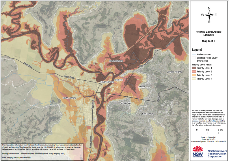
As reported earlier today, the NRRC finally released its "comprehensive flood hazard map" a key factor in determining who is eligible for House Buybacks, House Raisings and Retrofits (NRRC to release ‘flood hazard mapping’ today).
While the expectation was high among residents, the reality was disappointing with many people commenting on its lack of clarity.
"Comprehensive? You can't see the streets", was one Lismore App reader's comment, and "Clear as mud" was another.

The three Lismore areas severely impacted by the worst natural disaster in Australia's history in dollar terms were the CBD, South and North Lismore.
The map above shows most of South Lismore as a Priority Level 4 and 3 with small patches of Priority Level 2.
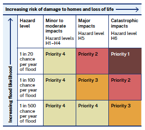
According to a table released by the NRRC late this afternoon and an explanatory document, homes in Priority Levels 1, 2 and 3 will be prioritised for House Buybacks.
A priority rating has been assigned to homes affected by the floods, where Priority Level 1 areas have the highest chance of being affected by, and experiencing the impact from, future floods.
Homes in Priority Level 4 will be prioritised for the House Raising or the House Retrofit stream if they are located at the low points in the landscape.
The NRRC identify priority homes by the likelihood of experiencing more frequent flooding and greater levels of property damage and risk to life due to flood depth and flow rates during events (hazard) than other homes in Lismore and the Northern Rivers.
Flood modelling data for the extent and possible impact of a 1 in 20 chance per year, 1 in 100 chance per year, and 1 in 500 chance per year flood events have been considered.
A property assessment will be needed to determine the best approach for each home in the House Raising or House Retrofit streams (for example, homes made of brick may not be suitable for raising)

A question that was being asked often in the community was what Flood Mapping documents are the NRRC using? More detail was released today:
The NRRC engaged an external consultant who specialises in natural hazards and resilience to develop the flood mapping and analysis.
The flood hazard analysis has been defined in accordance with the Australian Institute for Disaster Resilience Guideline. More information can be found via the Australian Institute for Disaster Resilience
(AIDR).
The NRRC also worked with specialist flood experts and a cross-government Flood Expert Advisory Panel including representatives from:
— NSW Department of Planning and Environment
— Infrastructure NSW
— NSW State Emergency Service
— NSW Reconstruction Authority.
Data from a range of existing sources has been carefully compiled and reviewed to develop the flood mapping and analysis including:
— flood studies prepared by local councils across the region
— information from a regional-scale flood model which covers rural areas where no council flood studies exist
— council survey data indicating the floor levels of homes which can be used to determine whether flood water is likely to enter a home in different scenarios
— flood records on the impacts of the 2022 flood on homes from the NSW State Emergency Service and other government and community sources.
This is the most comprehensive flood mapping and analysis available in the Northern Rivers and shows the relative risk to life for each neighbourhood.
The flood mapping and analysis is based on the best data currently available and will continue to change over time as flood studies are updated and new information is produced.
The NRRC said in a statement its method for determining the location of prioritised homes includes where the risk to life is greatest under most flood scenarios and are likely to be inundated by high and fast floodwaters.
Homes being prioritised under the Resilient Homes Program present the greatest risk to life to both residents and emergency response agencies sent to rescue them.
When the NRRC was established on July 1 2022 and the $800 million Resilient Homes ($700 million) and Resilient Lands ($100 million) Programs were announced in October last year, the CEO David Witherdin said there would be about 2000 House Buybacks, 2000 House Raisings and 2000 House Retrofits so 6000 in total. The number of registrations for this program is 6,471 as per the NRRC website.
Yesterday, Mr Witherdin mentioned the number of House Buyback Offers would be around 1,100 by the end of this month.
The question has to be asked, how can you nearly half the number of homes that are in high-risk areas in that time frame? All from new data?
Or could it be that the $700 million given to the NRRC by the Federal and State Governments is what Mr Witherdin has to play with and there is no more money forthcoming?
More to come.

