Tropical Cyclone Alfred update: Crossing expected later this morning as a low

Simon Mumford
07 March 2025, 9:28 PM
 Issued at 8:02 am AEDT Saturday 8 March 2025.
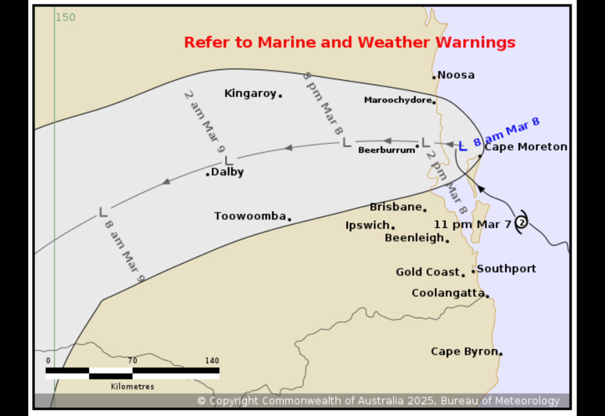
Tropical Cyclone Alfred is moving north northwest at 10 kilometres an hour and has continued to weaken as it approaches landfall.
Dean Narramore, senior meteorologist with the Bureau of Meteorology says Alfread is likely to weaken further in the coming hours and is expected to be below cyclone strength before it crosses the mainland, but is still going to bring "widespread heavy rain and gusty winds as it extends inland."
"With Tropical Cyclone Alfred just off the coast around Bribie Island and likely to weaken in the coming hours, it's likely to cross later this morning as a tropical low somewhere around the southern Sunshine Coast, or northern parts of Bribie Island, and will continue to track inland as a tropical low through this afternoon and into tonight, and then getting into the Darling Downs on Sunday."
Alfred brought some heavy rain overnight, especially to the Coffs Harbour region with Meldrum (west of Coffs) again recording over 200mm with 272mm and Dorrigo 243mm.
Lismore recorded 132.8mm to 8am, with some significant falls in the hills; Goolmangar 116mm, Nimbin 100mm, Terania Creek 155 mm, Huonbrook 123mm and Mullumbimby 159mm.
The Wilsons River at Lismore was 9.06m and rising at 7:30am and is expected to reach the major flood level later this morning. With forecast rain, Lismore is expected to reach 10.6m late Saturday morning. This is right on levee wall heights.
For the rest of the Northern Rivers:
The Richmond River at Wiangaree is currently at 11.67 metres and falling, above the minor flood level (11.00 metres). With forecast rainfall, renewed rises are possible along the Richmond River at Wiangaree and the river level may reach the moderate flood level (15.50 metres) during Saturday.
The Richmond River at Kyogle is currently at 15.54 metres and steady, above the moderate flood level (14.40 metres). With forecast rainfall, further rises are possible along the Richmond River at Kyogle and the river level may reach the major flood level (16.00 metres) during Saturday.
The Richmond River at Casino (automatic gauge) is currently at 11.00 metres and rising, below the minor flood level (11.90 metres). The Richmond River at Casino (automatic gauge) is likely to exceed the minor flood level (11.90 metres) Saturday morning. The river level may reach the moderate flood level (14.90 metres) late Saturday morning. Further rises are possible, with forecast rainfall.
The Richmond River at Coraki is currently at 4.36 metres and rising, above the minor flood level (3.40 metres). The Richmond River at Coraki is likely to exceed the moderate flood level (5.00 metres) Saturday morning. The river level may reach the major flood level (5.70 metres) Saturday afternoon, with forecast rainfall.
The Richmond River at Bungawalbyn is currently at 3.83 metres and rising, above the minor flood level (3.00 metres). The Richmond River at Bungawalbyn is likely to exceed the moderate flood level (4.50 metres) Saturday morning. The river level may reach the major flood level (5.00 metres) Saturday afternoon, with forecast rainfall.
The Richmond River at Woodburn is currently at 2.83 metres and rising, below the minor flood level (3.20 metres). The Richmond River at Woodburn is expected to exceed the minor flood level (3.20 m) Saturday morning. The river level is likely to exceed the moderate flood level (3.70 m) late Saturday morning and may reach the major flood level (4.20 m) Saturday evening, with forecast rainfall.
Most the strongest wind gusts were recorded in South East Queensland overnight. The Gold Coast seaway recorded 107 km/h and Brisbane airport 93 km/h.
Dean said we can expect widespread rainfall to continue near and south of where ex-Tropical Cyclone Alfred crosses in the coming hours.
"Widespread heavy rainfall is likely in South East Queensland and North East New South Wales, and as severe weather warning is current to cover this pretty much from Gympie all the way down to Coffs Harbor and extends inland, including the ranges and as far west as Toowoomba, Warwick and Stanthorpe, and South East Queensland and towards Glen Innes in New South Wales.
"Now these areas are likely to see heavy to locally intense rainfall, and we could even see damaging to locally destructive winds, particularly with any thunderstorms that do develop into this afternoon and this evening, and this widespread rainfall will continue to further exacerbate the flood threat through much of South East Queensland and North East New South Wales, which is of a concern with already many major flood warnings current in these areas."
We are not expecting to see conditions ease until late Sunday or probably into early next week. It will be a wet weekend as the north-easterly winds drag all the rain offshore into these areas. Rain should ease across NSW on Tuesday.
You can stay up to date with the latest BOM weather warnings and radar through the Lismore App Weather & Travel or directly through the BOM website http://www.bom.gov.au/.

