The latest from The Bureau including warnings and rainfall

Simon Mumford
27 September 2024, 10:27 PM
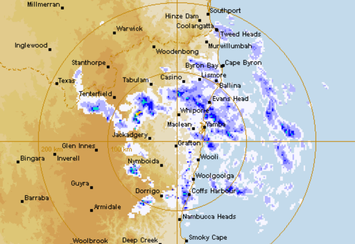
The rain continues to fall in Lismore and the Northern Rivers and will for the rest of Saturday. To 9am today, the Lismore Airport has recorded 78mm, on top of the 53.4mm to 9am on Thursday.
Angus Hines, one of the senior meteorologists at the Bureau of Meteorology, says Coffs Harbour and Lismore have had the highest rainfalls in the last 24 hours.
"The heaviest falls through the past 24 hours have been in the far northeast, around the Northern Rivers district and the far north of the mid-north coast of New South Wales. In particular, we've seen a lot of rain pile up around Coffs Harbour, with about 110 millimetres falling since 9am on Friday; a little further north, Lismore has had about 90 millimetres in the same time period."
"More broadly speaking, many areas in the northeast of New South Wales have seen between 30 and 60 millimetres of rain across about the last 24 hours, strong winds have also been blowing up the northern New South Wales coast, particularly strong around Cape Byron, with top gusts through the night of about 100 kilometres an hour.
"It will be another very wet day around the northeast of the state on Saturday; that rain is expected to continue through much of the day today, once again, the heaviest rainfall is likely to be in the far northeast of the state, around the Northern Rivers and perhaps the far north of the mid-north coast forecast district. These places could see another 60 to 80 millimetres of rain through the day on Saturday and into the early hours of Sunday morning. A couple of places might see a little bit more than that as well.
"The rain has been caused by a big influx of moisture earlier in the week, which brought the rain to the region as a North West cloud band bought tropical conditions across Queensland and into northern New South Wales. This was then added to by a cold front that raced up the New South Wales coast, bringing cool and wintry conditions.
"These initial weather systems have started to ease away. But we're seeing prolonged wet weather due to the development of a low pressure system, which is just off the east coast of Australia at the moment, which is going to continue to feed the wet conditions onto the country through the day. On Saturday, during Sunday, this low-pressure area will weaken and move away from the coast, and that's when we do expect to see the conditions ease across the eastern part of the country."
As for warnings, there is still a Flood Watch for the Wilsons River for minor to moderate flooding. The Wilsons River is 1.31m at Lismore at 8:39am. The minor flood level is 4.2m. The Richmond River has a warning for minor flooding.
Angus said flooding is likely to occur over the next couple of days.
"We're still waiting to see how these rivers respond to the current and upcoming rainfall, and these flood watches could turn to flood warnings at any stage of the day today. So people in and around those river networks in North East New South Wales do need to take care and stay up to date with the latest flood information on the Bureau's website."
The severe weather warning is still in place for damaging winds along the northern coast from Coffs to the Queensland border. There could be wind gusts up to 90 or 100 kilometres an hour. They are expected to ease this evening.
There is also a coastal hazard warning running along the coast of northern New South Wales for damaging swell, as expected along this coastline, very heavy surf could lead to localised damage and possible coastal erosion for exposed parts of that coastline.
There is also a sheep grazier warning for the Northern Rivers, which is something we don't see very often.
As for when conditions will ease?
"We're expecting wet and windy weather around the eastern part of the country to continue through most of the day on Saturday, but there will be a significant easing trend to that weather system overnight tonight and into Monday morning. The driving low-pressure area will weaken and move away from Australia.
"We'll see both the rainfall and the strong winds significantly wind down overnight tonight, making for a bit of a calmer and more settled day on Sunday, although it won't be completely dry. We still anticipate showers around these areas, but the rainfall will be significantly lighter on Sunday. The wind will die down as well."
You can keep up to date with the BOMs warnings, forecast and radar through the Lismore App Weather & Travel button Weather and Weather Radar.

