The Big Map makes a return to Lismore as we learn more about flood preparedness
Simon Mumford
09 December 2024, 7:00 PM
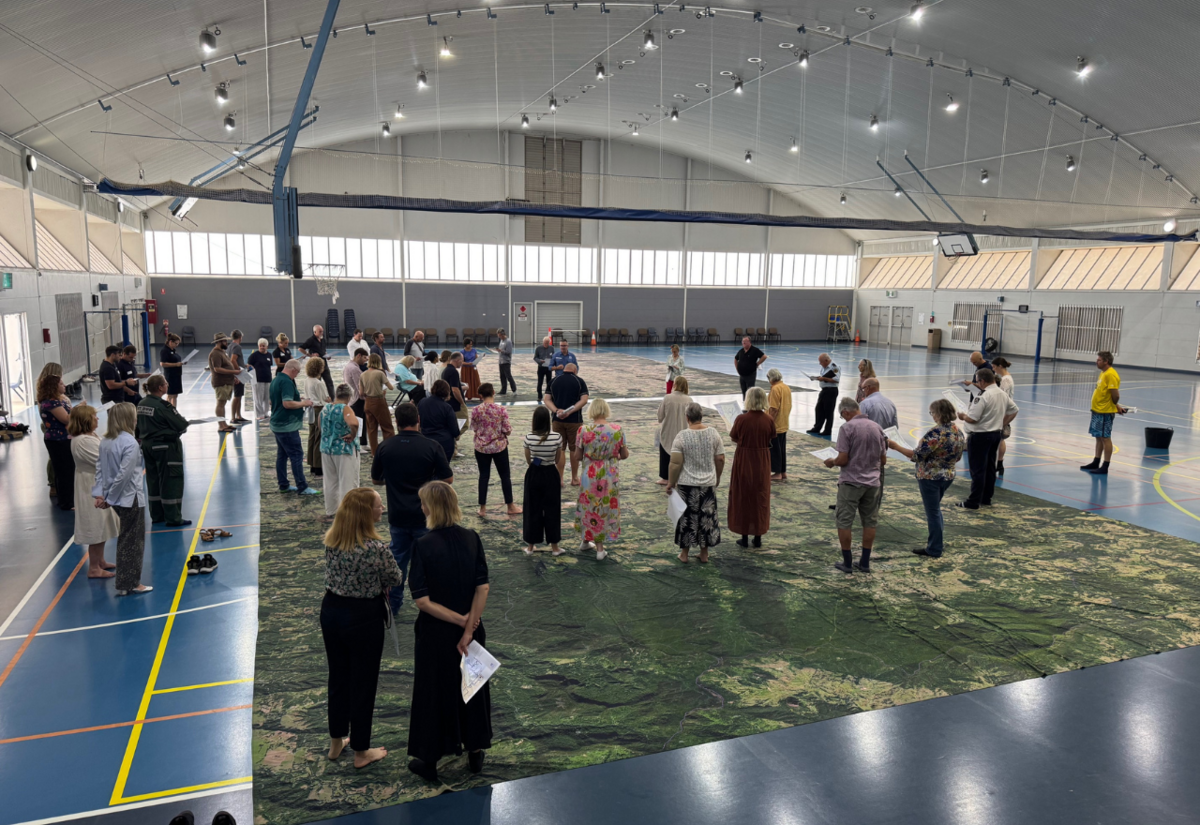
 People listening to information on the Big Map at GSC today
The Big Map made a return to GSAC today after an initial visit in September 2022, about six months after the big flood.
It was acknowledged by Andrew Moss from Disaster Relief Australia (DRA) that the first visit was too soon to have any meaningful impact on residents as the emotional trauma was still too real at the time.
"There was still a lot of pain. There was still a lot of hurt in the community. There were still a lot of community members going; how the hell did this just happen?"
The goal of the Resilient Towns Initiative, as the Big Map is officially called, in the Northern Rivers is to help residents better understand how flooding occurs in the entire Richmond River catchment area and for them to be better prepared for when the next flood hits so people can make better, more informed decisions.
Member for Lismore Janelle Saffin, who made the opening speech, said the Big Map clarifies where you are in the Richmond River catchment and what effect it has on your home or your village.
"When you visually see the whole catchment and see where you are in it and your CBD or your village, it just helps you understand better where the water's coming from and what you don't know and what you need to know because we all have to prepare ourselves. But equally, it shows what's missing in the formal systems as well, and that's part of what we need to do to prepare better.
One of the RA's legislated objectives is preparedness, so the RA is working with different agencies to achieve this.
"The Red Cross is one of them, and the smaller mitigation stuff that's happening in the NRRRP. The SES has also stepped up from 2022, and you can see that they come out, I wouldn't say almost ahead of the BOM, but they do let us know locally what's going to happen, which is a good thing."
Yesterday's information session was led by Andrew Moss, "Mossy", as he likes to be known from the DRA.
DRA is a not-for-profit organisation that unites the skills and experience of Australian Defence Force veterans with emergency services specialists to rapidly deploy disaster relief teams in Australia and around the world in the wake of disasters. They have held over 50 of these Big Map sessions right across Australia for different disasters. They have no political affiliation.
Mossy was running the coordination centre with the Queensland Fire Emergency Services the day before our big flood. He was looking at the impacts it could have in Gympie before moving to the Gold Coast and the impact of rising waters at Tallebudgera Creek and Currumbin Creek.
He explained how the rainfall on 28 February 2022 could have been so different. It all depended on how long the weather system stayed over one city or town.
"We actually did a big map in Currumbin and Tallebudgera on Saturday. And it's literally a matter of 38 minutes. 38 minutes of where that weather system stayed in the air as it came across the border, where it dropped a large amount of rain at the top of Terania Creek. 1400 ml in a certain period of time.
"38 minutes earlier, that could have dropped on that (the Queensland) part of the border, and that would have impacted Tallebudgera and Currumbin Creek, and they are still trying to work out what those impacts may have been.
"If that system had stayed in the air for another 42 minutes, it would have cleared the Richmond and actually landed at the top of the Clarence, which would again be a completely different disaster scenario, which would have had Grafton and all of the southern parts of the Clarence Valley under full major flood alert.
"So, when you come back to the flood event, and you start to prepare, and you start to talk about the preparation space, in terms of the bigger picture strategically, it's all a matter of minutes. If that had landed 38 minutes earlier, you would have been watching the Gold Coast, the hinterland, that part of the state would have been in a world of hurt. Unfortunately, it landed in your backyard."
As we mentioned, Mossy and the DRA have run over 50 Resilient Town Initiatives throughout Australia. He said that every other council and community is looking at how we step ourselves out of this recovery and better prepare ourselves for future events.
"Unfortunately for you, you are now the leaders in the flood space for two things. A, what not to do, and B, what to do. The world, definitely Australia, other councils, other areas down south that have flooding as a serious impact are looking to list more as leaders. How are they going to manage that? And how are they going to deal with that? They then wait for the outcome and go, yeah, that probably is not how we'll approach that. We'll actually come at it from a different angle. Don't be afraid of that. That's just how it is.
"It wasn't too long ago that I was in Queensland Reconstruction Authority, and we had a flood event in our own little valley, where for the next 10 to 15, 20, 30, 40, 50, 60, years, the same discussion will be asked for people who live in that valley. Why did you buy my house and not the one next door? Right? They'll be asking that same question for another 50 years. You're now going into that as well in this part of the world."
Mossy then went through points we all know too well. We live on a floodplain, and the rain falls in the upper catchment and makes its way to Lismore, Wiangaree, Casino, Coraki and Woodburn before heading out to the ocean. He said the catchment was designed to be fast-flowing so the water could move quickly through the system.
As we now know, slowing the water flow down in the upper catchment is going to be one of the key mitigation measures that could take a metre or a metre and a half off a major flood in Lismore, Coraki and Woodburn.
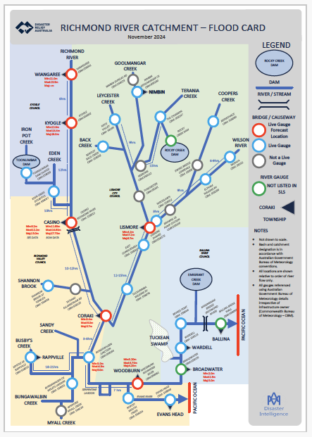
Finding the rain gauge level information in the Richmond catchment can be difficult when you want to monitor conditions during a severe weather event. You need to search around the Bureau of Meteorology website, which is not an easy task. DRA has made a Flood Card to make this process simple.
Mossy explained that there are three types of gauges in the catchment.
"There's the data gauge, information gauge and the forecast gauge. Generally, what happens is your data gauges can also act as rain gauges, depending on where they are, but in this particular case, your information gauge can also have a minor, moderate and major flood height attached to it. But, because it's not a forecast flood gauge, you're actually not going to get a broadcast flood alert from the Bureau; that's only ever going to come from your forecast gauges.
"So, it means a lot of information is going to Lismore, going to someone, the agency, the Bureau, and then from there that it starts to provide that flood forecast to downstream.
There are a number of 'Not Live Gauges' in the Lismore LGA, such as Keerong, Tuncester and Ewing Bridge, Corndale. This means that the landowners have to get up at any time and get a reading from the gauge to report it to the SES or BOM.
"For Lismore, the ability to provide you with that flood water and that flood forecast, you won't get that unless you know Annie who's upstream. Annie, what's going on? Can you tell me? Unless you've got her on speed dial or someone else up there, then there's other ways to get that information through other sources, Facebook, Twitter, other community groups that are now starting to keep that information. But with that, there is a kind of misinformation as well."
Mossy could not provide any information on rain gauge updates. So, it was unknown whether the Not a Live Gauge would become a Live Gauge in the future.
He did say there is a PDF program that people can use to follow rainfall down various tributaries.
"Once I send you the link for it digitally, you can just upload it, and it's yours on your computer. And how I like to have it is during a flood event, or when I'm working with councils or catchments, is just tell communities, have it up on your computer screen. You know where the rain's falling, then have a look at the gauge and see where the water's going up and then go, okay, I can actually see water going up there. There's no water at this gauge. So somewhere, there's water now travelling down the river system."

The Big Map session is about preparedness.
Are we better prepared than in 2022? Yes.
Are we fully prepared for another 14.4m flood? No.
Is every new resident who has moved to Lismore and the Northern Rivers in a vulnerable area aware of the flood risks? Do they have a flood plan? Are they prepared?
Time will tell.