Severe Heatwave Warning extends to Friday and more storms possible

Simon Mumford
25 November 2025, 7:02 PM
Temperatures will once again be in the mid-thirties for the next four days, so the Bureau of Meteorology has extended its Severe Heatwave Warning to Friday, November 25.
Overnight minimum temperatures will be in the early twenties, with a peak of 23 on Thursday morning.
Western parts of the Northern Rivers, including Lismore, will move from a Low to a Severe Heatwave Warning on the Severity Map today (Wednesday). On Thursday, that will extend to all of the Northern Rivers and include Ballina and Byron Bay. Towns just north of Evans Head, like Wardell and west of Yamba, like Maclean, will move to an Extreme Heatwave Warning.

Safety Advice:
- Severe heatwaves can be dangerous for many people, especially older people, babies, children, pregnant and breastfeeding women, people with medical conditions and people who are unwell.
- Seek a place to keep cool, such as your home, a library, community centre or shopping centre.
- Close your windows and draw blinds, curtains or awnings early in the day to keep the heat out of your home.
- If available, use fans or air-conditioners to keep cool.
For further safety information before, during and after heatwaves, visit https://www.ambulance.nsw.gov.au/in-the-community/warnings
The high temperatures are playing their part in creating more thunderstorm activity on Wednesday. The BoM says the thunderstorms are being driven by areas of low pressure across eastern Australia that are tapping into moisture from areas further north and dragging it down into storm areas, which is combining with the very warm conditions. The troughs are acting as a trigger for thunderstorms.
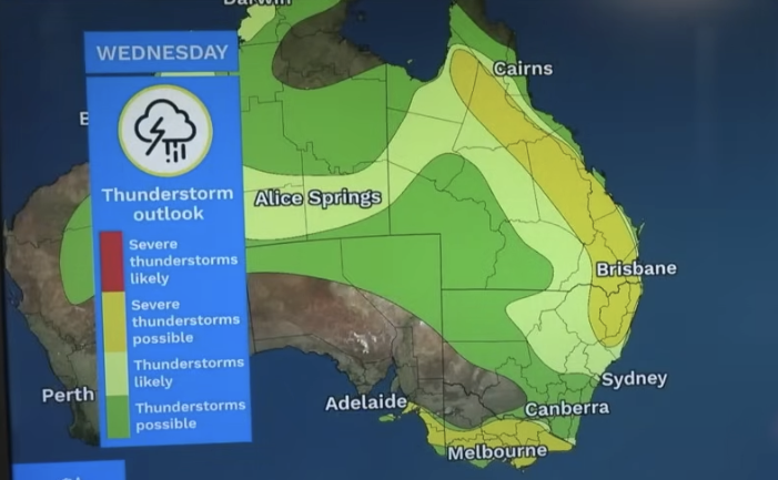
(The BoM Thunderstorm Outlook map for Wednesday)
Check out this thunderstorm photo from last night, sent in by Lismore App reader Kyle. It is taken from a drone in Goonellabah looking south.

As for when conditions will cool somewhat? Saturday is another hot day, with a maximum temperature of 35 degrees, before Sunday drops to 31 degrees.