Renewed river rises possible today depending on rainfall

Simon Mumford
08 March 2025, 10:00 PM
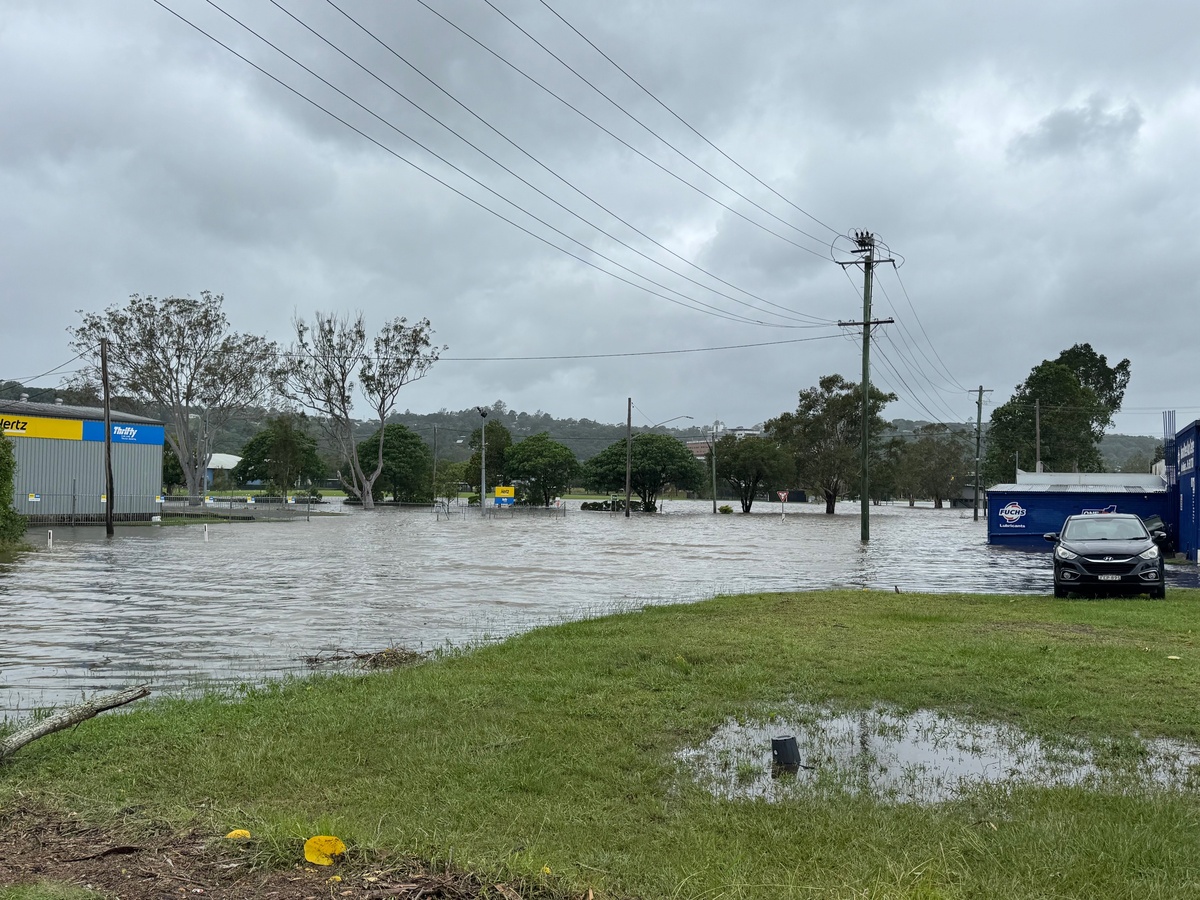 Zadoc Street looking toward the playing fields yesterday.
Residents in Lismore and the Northern Rivers have an end in sight from the effects of ex-Tropical Cyclone Alfred, now a low pressure system. Dean Narramore from the Bureau of Meteorology said the weather should clear on Wednesday.
Until then, we can expect some heavy rainfall which will become more isolated as we get through Sunday.
Ex-Tropical Cyclone Alfred moved on shore last night, around 9 or 10pm over Bribie Island in Queensland and continued to move inland. That is after it stalled for about 12-18 hours on Saturday just off the coast due to a weakening high pressure system in the Tasman Sea that was steering Alfred. A new high pressure system has moved into the Tasman Sea and resumed its westerly track inland over South East Queensland.
It has now washed out and ended, and now it's just a week low as it continues moving further inland through South East Queensland, bringing a lot of rain.
That ended a 16-day period where Tropical Cyclone Alfred developed on the 24th of February and then weakened last night offshore before crossing overnight on Saturday, 8 March 2025.
"Today is all about the rainfall that's likely to be experienced across much of South East Queensland and far north east New South Wales," Dean Narramore said.
"We can see widespread falls of 50 to 150 millimeters in these areas, with isolated falls up to two, three, even 400 millimeters possible, particularly with any intense thunderstorm activity or any convergence zones where we have this really heavy rainfall concentrating over a certain point. So that's what we'll be watching today.
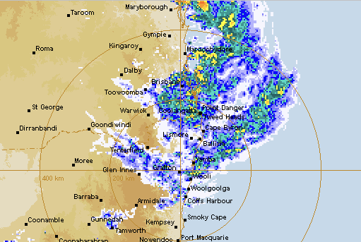
"And those kind of rainfall numbers on top of everything that's already fallen, could lead to widespread flash and riverine flooding in South East Queensland and North East New South Wales today.
"We're going to see all this rain and activity kind of spread inland, as we move through today. And then an upper trough is going to move in from Central Australia and drag that activity into northern New South Wales on Monday and Tuesday. But we're still likely to see showers and thunderstorms on Monday and Tuesday in South East Queensland, while rain and storms continue in New South Wales.
"Finally, by Wednesday, the weather system will finally shift all this wet weather to coastal parts of New South Wales, further south, and then find a clearing mid to late week."
In Lismore and the Northern Rivers, there were some heavy falls in the upper catchments, with Terania Creek recording a further 113mm, Huonbrook 130mm, Mullumbimby Upper Main Arm 141mm.
The Wilsons River has fallen to 8.84m overnight, from a high of 9.3m yesterday afternoon. However, the Bureau has continued its major flood warning.
"Moderate flooding continues along the Wilsons River at Lismore, where river levels peaked Saturday afternoon. With forecast rainfall, renewed river level rises are possible at Lismore, and river levels may reach the major flood level during Sunday.
"Further heavy rain is still possible over the Northern Rivers with ex-Tropical Cyclone Alfred, and there remains a risk of river levels at Lismore reaching levee heights if intense rainfall develops.
"A Severe Weather Warning is current for NSW including the Wilsons River catchment."
THE RICHMOND RIVER
For other parts of the Northern Rivers, The Bureau said at 6:50am Sunday:
Major flooding is occurring along the Richmond River at Coraki and Bungawalbyn and minor flooding is occurring at Kyogle and Casino. Moderate flooding may occur at Kyogle and Woodburn. Minor flooding may occur at Wiangaree.
The Richmond River at Wiangaree is currently at 6.64 metres and falling, below the minor flood level (11.0 m). With forecast rainfall, renewed river level rises are possible, and the river level may reach the minor flood level (11.00 m) during Sunday.
The Richmond River at Kyogle is currently at 11.92 metres and falling, above the minor flood level (12.00 m). With forecast rainfall, renewed river level rises are possible, and the river level may reach the moderate flood level (14.40 m) during Sunday.
The Richmond River at Casino Road Bridge peaked at 11.02 metres around 07:45 pm Saturday 08 March and is currently at 10.67 metres and falling, above the minor flood level (9.20 m). The Richmond River at Casino Road Bridge may remain above the minor flood level (9.20 m) during Sunday.
The Richmond River at Casino (Automatic Gauge) peaked at 13.70 metres around 08:00 pm Saturday 08 March and is currently at 13.42 metres and falling, above the minor flood level (11.90 m). The Richmond River at Casino (Automatic Gauge) may remain above the minor flood level (11.90 m) during Sunday.
The Richmond River at Coraki is currently at 5.79 metres and rising, above the major flood level (5.70 m). The Richmond River at Coraki may reach around 5.90 metres Sunday morning, with major flooding. Further rises are possible, with forecast rainfall.
The Richmond River at Bungawalbyn is currently at 5.28 metres and rising, above the major flood level (5.00 m). The Richmond River at Bungawalbyn may reach around 5.40 metres Sunday morning, with major flooding. Further rises are possible, with forecast rainfall.
The Richmond River at Woodburn is currently at 3.64 metres and rising, above the minor flood level (3.20 m). The Richmond River at Woodburn may exceed the moderate flood level (3.70 m) Sunday morning. The river level may reach around 3.90 metres late Sunday morning, with moderate flooding. Further rises are possible, with forecast rainfall.
As the NSW SES warnings have continuously said, don't drive through flood waters.

