Persistent rain on the way: BoM warns stay up to date

Simon Mumford
18 August 2025, 10:00 PM
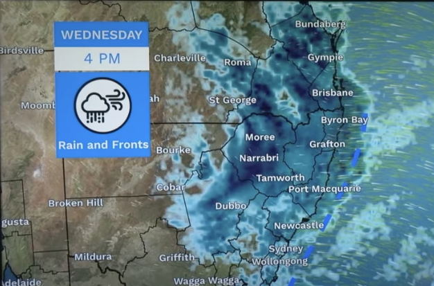 The BoM's weather forecast for Wednesday
As forecast, the short run of clear blue skies ends today as an East Coast weather system shifts into overdrive throughout Wednesday and Thursday.
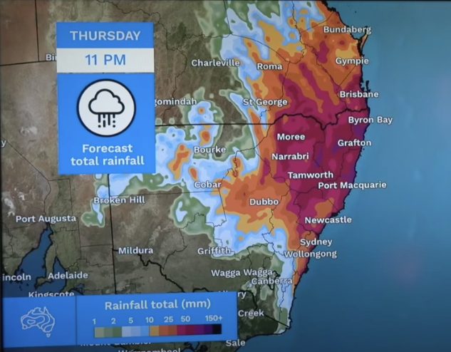
The worst of the weather looks to hit the mid-north coast again, with a number of Stay Informed flood warnings issued for Coffs Creek, Thora, Coutts Crossing, Glenreagh and Bellingen. The Bureau of Meteorology (BoM) is forecasting up to 185mm for Coffs Harbour and Port Macquarie over the next four days.
For Lismore and the Northern Rivers, the situation is slightly lower than our southern neighbours. At 6 o'clock last night, the BoM was forecasting up to 120mm throughout Wednesday, Thursday and Friday, by 10pm that had increased to 150mm. The lower end of that scale is 18mm.
However, Angus Hines, Senior Meteorologist with the BoM, warns us that the situation could change as the weather event gets closer. Usually, the further away the weather event is, the hazier the forecast.
(The potential cumulative rainfall along the NSW east coast 6pm Monday from the BoM)
"I wouldn't take these numbers and lock them in stone just yet," Angus said, "they might shift up, they might shift down."
When speaking about the current flood watches around the mid-north coast, he said, "I would like to reiterate once again that we could see changes to this flood watch, potentially new rivers throughout northern NSW and even southern Queensland could be added into the flood watch as our information changes."
The message for Lismore and the Northern Rivers is to stay up to date with the weather forecast and the warnings. The Lismore App will keep you informed of any developments.

