New flood report modelling shows LCC have big decisions ahead
Simon Mumford
17 January 2023, 8:01 PM

A new report that will be discussed at next week's Lismore City Council Floodplain Management Committee meeting demonstrates the difficult decisions that Council and other bodies like the Norther Rivers Reconstruction Corporation and the newly formed NSW Reconstruction Authority need to make during 2023.
Lismore City Council (LCC) had engaged ENGENY Water Management (A multi-disciplinary Engineering & Environmental Consultancy company with offices all over Australia) in late 2021 to update LCC's Floodplain Risk Management Plan. The events of February 28 followed by the March major flood put part of the scope of work temporarily on hold. However, an interim report has been submitted to LCC for Land Use Planning and Development Control.
This report will be discussed by the Floodplain Management Committee next Tuesday (24 January) who will then make recommendations to LCC Councillors as to which areas of land Lismore should be developing in the future. This then forms part of the critical Development Control Plan that caused so much debate at the December 13 2022 council meeting.
What makes this complicated for councillors is the varying simulated heights used in the modelling. Depending on what annual exceedance probability (AEP) is used determines the planning and development that LCC will allow. The modelling included 10%, 5%, 1%, 0.2% AEP which includes the current state government allowance and the newer 2090 climate change numbers.
Basically, ENGENY has created a scale using the depth and water velocity of a flood ranging from H1 (generally safe) to H6 (unsafe for people and vehicles with all building types considered vulnerable to failure).
When you look at the 1% modelling (so a 1% chance of a major flood event occurring in a year or colloquially one-in-a-hundred years) which is well below the February 28 2022 levels, you can see that the CBD and North Lismore are mostly H5 and H6 with South Lismore H3 to H5 with a small bit of H6. This is what the Lismore community used to call an extreme flooding event so around the 13 metre mark.
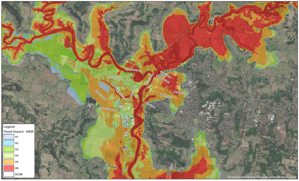
(1% AEP is looking at flood heights to a maximum of 12.9m)
ENGENY mentioned that Lismore's current Flood Planning Area (development in flood prone areas) was developed based on the 1% AEP back in 2012 from the Local Environment Plan. The current Lismore Flood Planning Level is 1% plus a freeboard (margin) of 500mm.
As we now know, the game has changed drastically. How much H5 and H6 is acceptable to live and/or work in the floodplain?
The options ENGENY are suggesting to council are below.
Consideration of any amendments to the Flood Planning Area (FPA) and Flood Planning Level (FPL) within the Flood Liable Area (FLA) are at the discretion of Council, with potential options including, but not limited to;
1. Retainment of the 1% AEP plus 500 mm freeboard for the FPL.
2. Adoption of the 1% AEP 2090 Climate Change level plus 500 mm freeboard for the FPL. It is noted that the 1% AEP 2090 Climate Change levels are generally 500-600 mm above the current scenario 1% AEP flood levels in Lismore).
3. Adoption of a flood event between the 1% AEP and the 1:2,000 AEP flood event as the FPL.
4. Adoption of the February 2022 peak flood height as the FPL, estimated as sitting between the 1:2,000 AEP and 1:10,000 AEP design flood levels.
5. Consideration of different FPLs for different land uses, such as residential versus commercial, could be also be incorporated.
As the flood heights rise you can clearly see the amount of H6 and H5 within the floodplain increases.
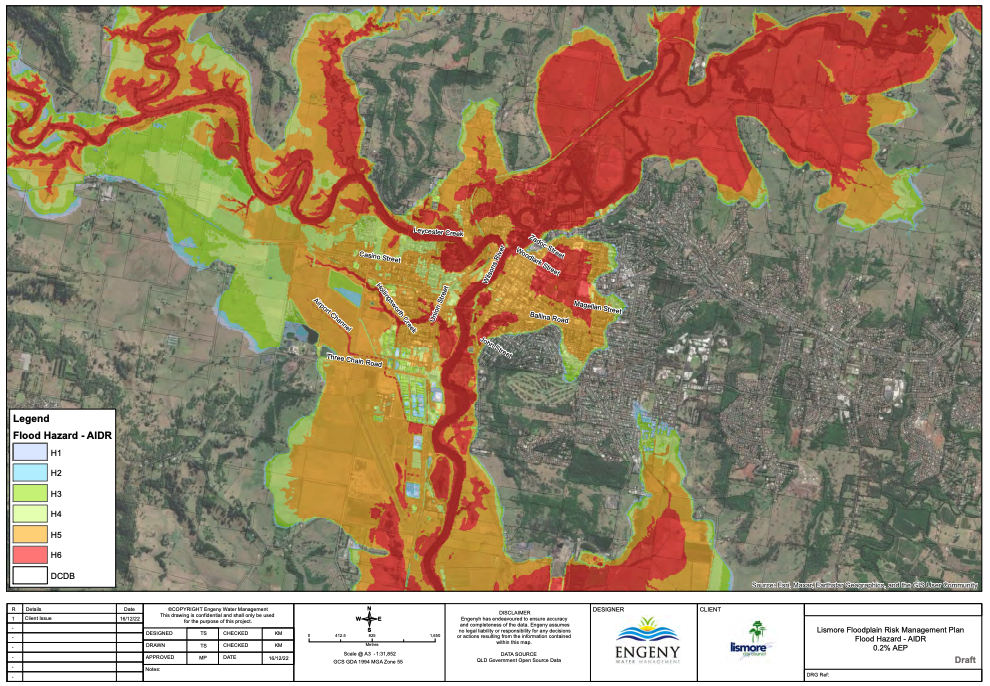
(0.2% AEP is looking at flood heights to a maximum of 13.5m)
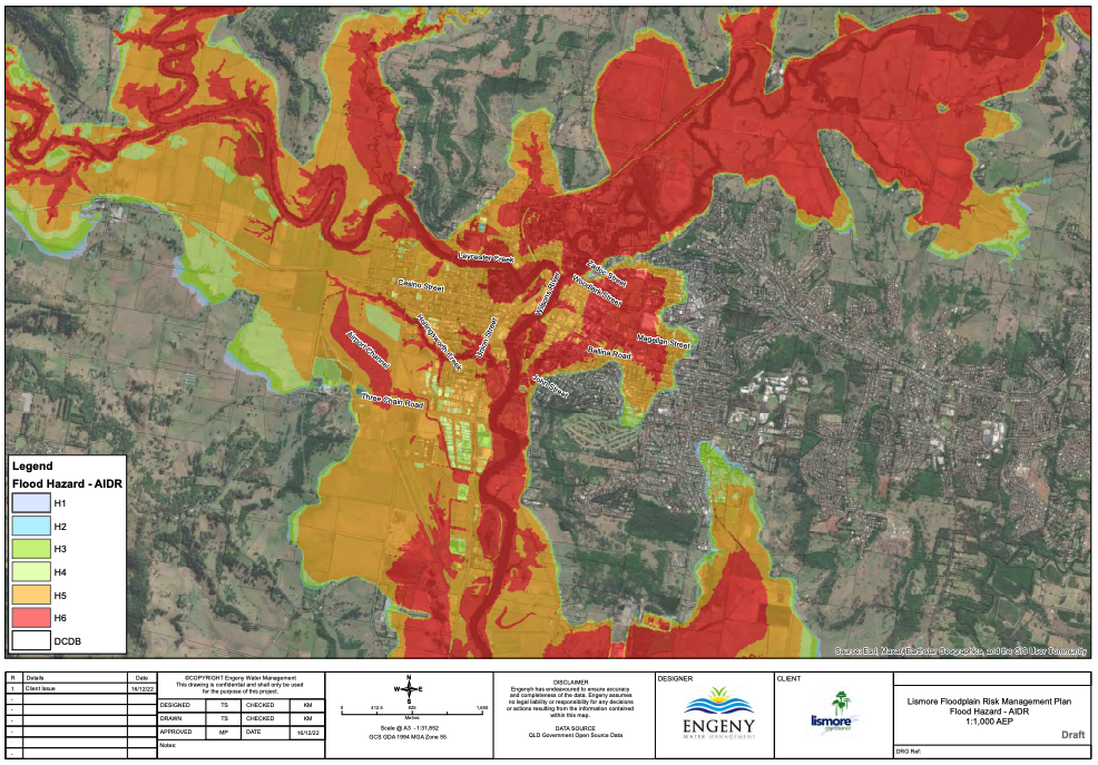
(1:1,000 AEP is looking at flood heights to a maximum of 14.3m)
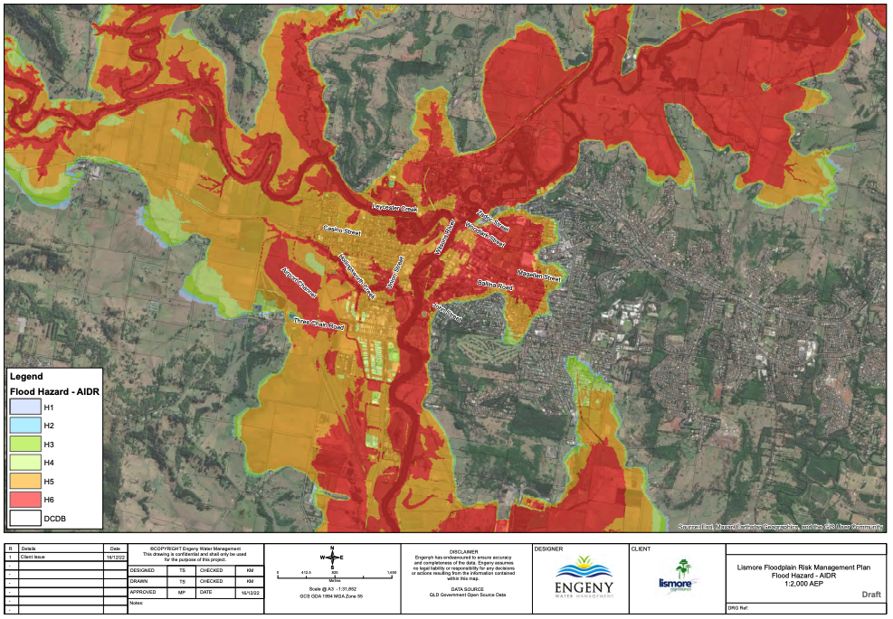
(1:2,000 AEP is looking at flood heights to a maximum of 14.6m)
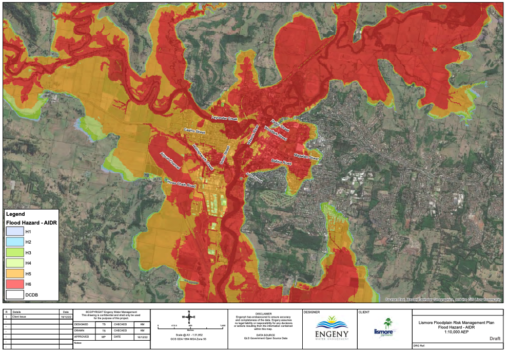
(1:10,000 AEP is looking at flood heights to a maximum of 14.8m)
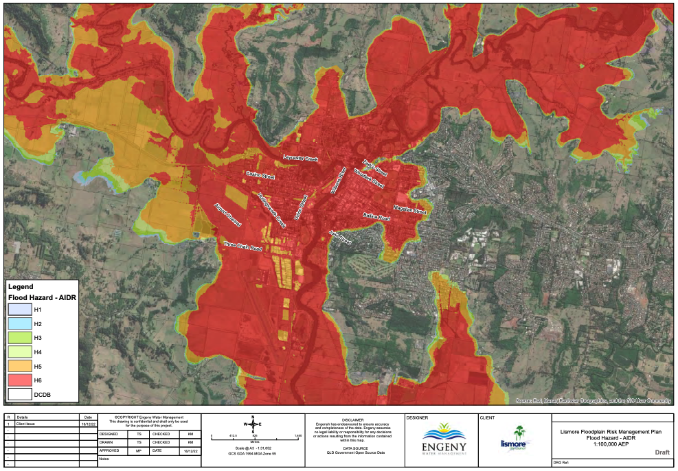
(1:100,000 AEP is looking at flood heights to a maximum of 16m)
The question for Lismore City Council to answer is what Risk Management Plan do they adopt to base future planning and development on.
The current 1% is clearly unacceptable or none of the governing bodies would be having these sort of discussions.
Is the 1% Climate Change 2090 acceptable given it is 500-600mm above the current levels?
When assessing the risk, LCC needs to take into consideration flood hazard, evacuation routes and the effects of climate change. ENGENY mention worst case scenarios were used with an increase in rainfall intensity of 19.7% to account for a temperature increase of 4.3 degrees by 2100.
Another consideration is the frequency of flood events.
February 28 2022 was easily the highest flood level in Lismore's white settler history at 14.4m. Officials will take into consideration the likelihood of that event occurring again given the effects of climate change.
London has moved to planning level of 0.2% AEP (or 1 in a 500 year flood) for land adjoining the Thames estuary and many parts of the Netherlands are using planning levels of 0.1% (1 in 1,000) for a coastal flood event.
What will Lismore City Council recommend?
To view the full ENGENY report go to the LCC website,click on council & engagement then business papers and the Lismore Floodplain Management Committee pdf document or simply click here.

