Health of our waterways is being assessed using Lidar imagery

Lara Leahy
25 September 2024, 9:00 PM
 LIDAR river bank security analysis - “The red spots are where there's been a change in the volume, which we can interpret as erosion.” (Image Credit: Andrew Brooks, Griffith University)
Improving the future health of our waterways has taken a big step forward with the implementation of the LIDAR data that has become available with the release of the first-ever CSIRO Flood Mapping Study for the entire Richmond River catchment.
Rous County Council are analysing the most vulnerable parts of the Wilson / Richmond Catchments system - approximately 5,500km of waterways, comparing it with any data previously available to determine the weakest points of the catchment.
Anthony Acret, a project director at Rous has just awarded a tender to the Precision Erosion and Sediment Management Group from Griffith University, led by Associate Professor Andrew Brooks. A team will coordinate the data, including Professor Kirstie Friyars from Macquarie University in a joint effort.
Anthony says, “It's going to be massive increase in our level of understanding of the nature of those issues across the catchment; it will then allow us to be much more strategic.”
Prof Brooks outlines the basis for the project, “We're primarily interested in where all the sediment is coming from in the catchment. We're particularly looking at the channel network.
“We're doing an analysis with repeat LIDAR data where you can measure actual erosion within the channels. We're also mapping all of the vegetation up the river corridor.”
Lidar geomorphic change detection will highlight the areas subject to the worst erosion over time, and suggestions will be made as to the best way to remedy all areas of concern. This includes erosion and land slips.
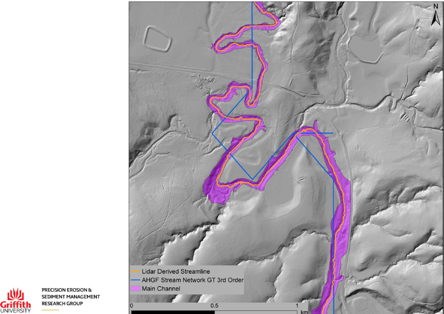
(What the Lidar imagery looks like. The blue line is where the waterway is on maps. The actual flow of the river is purple. Note: you can see other areas where water will pass over land, but these are either too small or not permanent and not included in the assessment. Image Credit: Andrew Brooks, Griffith University)
The land being assessed is primarily the riparian areas surrounding waterways in rural/agricultural areas. Channel erosion is said to contribute more than 80% of sediment in floods.
“We're looking at the third order waterways and above, which are the bigger channels," says Prof Brooks.
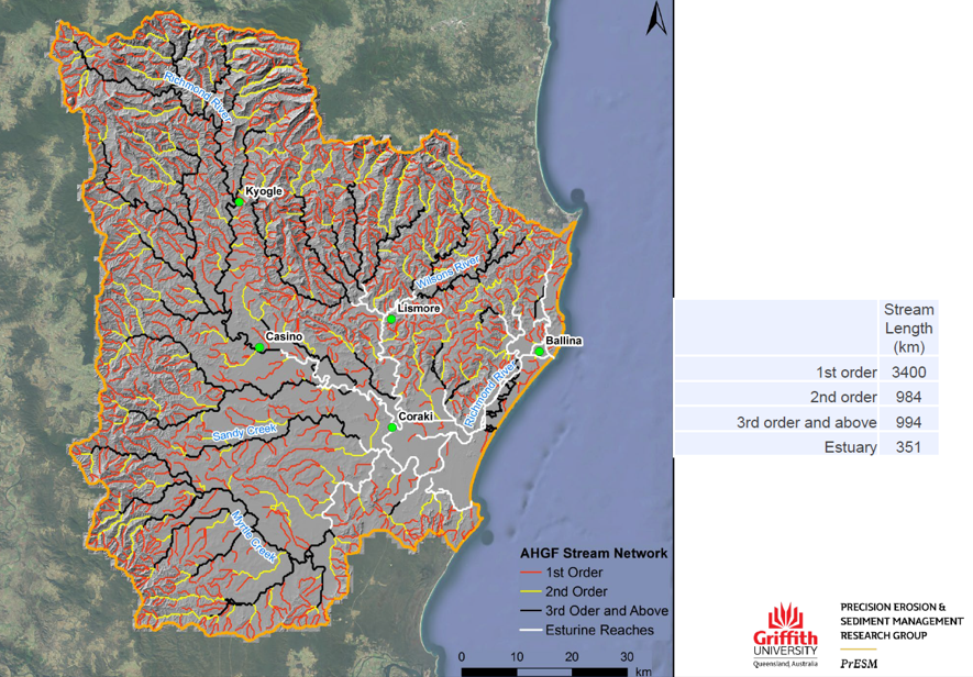
(The study covers almost 5,500 km of waterways. Image Credit: Andrew Brooks, Griffith University)
The waterways will be divided up into 1.5km segments for a detailed analysis. The vegetation making up the riparian zone will be assessed for adequacy and stability.
Prof Brooks explains, “The great thing about LIDAR data is you can just remove the vegetation and leave it with the bare ground. Or you can have the vegetation in.
“The first part of the job is to define the channel area. And what we're really focusing on is mapping all the channels, and then we work out what we can define as the riparian zone.”
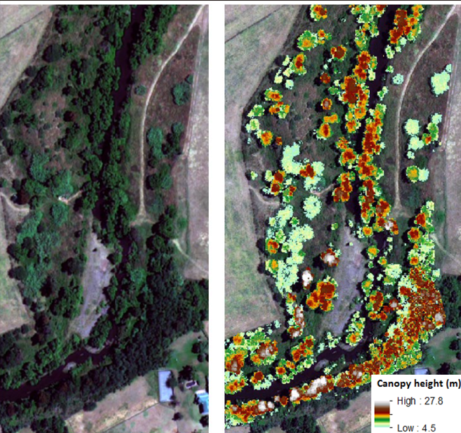
(Lidar imagery of vegetation in the riparian zone. Image Credit: Andrew Brooks, Griffith University)
“That is based on the tree heights; they are referenced sites.
“What we're trying to look for is what the forest used to be like on this bit of river. The best thing to do is to try to recover that.
“In the past, trees might have fallen over, and some of the trees would end up in the channel. So those trees there have and have a potential influence on the channel, as well as their roots.
“ We can even tell some places where the vegetation cover is going backwards, whether that is from flood or human influence at the banks.”
To get a holistic picture, another team will be assessing the estuary - the tidal aspects of the river, which covers around 950km. The Wilsons River that runs through Lismore city is tidal and will be a part of this study.
Anthony is very pleased with this outcome, as it has been difficult historically to get funding and politics to align to get complete knowledge of our waterways.
“Fisheries are doing a similar project in the estuary, which will really work together to get the whole picture. The meeting point will be around Boat Harbour, upriver from Lismore,” says Anthony.
The upper areas of the catchment are vital to understand and make secure for all the waterways downstream.
This is the first time the whole of the waterway will be assessed in this detail.
“We're doing the analysis using the LIDAR data of erosion that's happening between different LIDAR surveys. There's LIDAR data going back to 2010 and so what we do is, we compare it with the most recent one, or we can look at different little slices depending on how much data there is.”
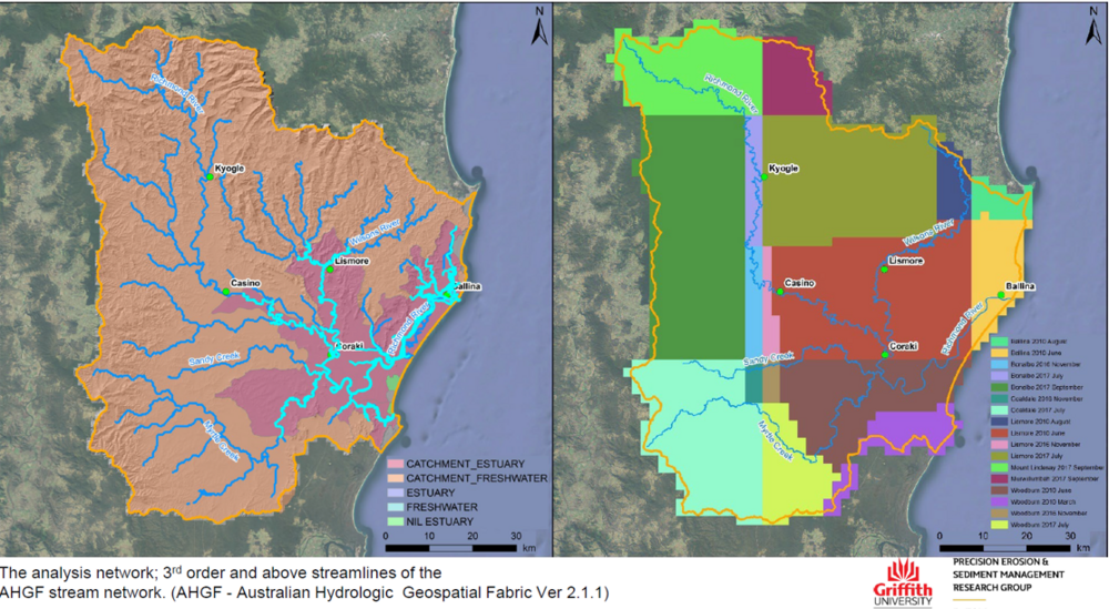
(The extent of the study, left, and precious data available for comparison, right. Image Credit: Andrew Brooks, Griffith University)
The information generated is used to determine areas that will recover with habitat regeneration. Some will need a lot of work and some, “areas that don't need intensive education, but with a little bit of additional help that will bring those areas back into better health.
“We're adding to the knowledge base, and then it'll become a resource for future management.”
Anthony speaks about what will happen with this information, “After this work, we set up a team program for the coastal management program. This work will allow us to be really on the front foot and much more strategic about the work to do.
“In the past, we've been criticised for being quite opportunistic and just going with what we can rather than being really methodical about it.”
This interview was at the end of the Richmond River Collaborative Partnership meeting. Anthony talks about how this information will affect more than the decisions made by Rous.
“The learnings that we get through this (project) are going to assist all catchment stakeholders.
“It will be made public, though we aren't sure how that will happen at this stage.”
Andrew is pleased about being involved. Although he lives in the Wilsons catchment, most of his analysis work has been in Queensland. He is happy with his part to play: “We've got 12 months to do this, and we'll do a lot in that time.”
