Flood Readiness: Are We Better Prepared? - Part 8 Lismore City Council

Lara Leahy
30 April 2024, 9:02 PM
 Lismore City
The Flood Readiness - Are We Better Prepared? series covers key organisations that play a vital role in pre-flood warnings and in the rescue & recovery after a major flood. We are asking those organisations to let us know how the 2022 floods and Flood Inquiry have changed their procedures and processes so people will experience better outcomes.
So we know what to expect when the unexpected happens next.
Today, we look at local government, Lismore City Council.
***
Lismore City Council, as the local government body responding directly to the people’s needs, plays a vital role in difficult times. In addition to communication, they have told us they employ flood risk and mitigation strategies to protect their electorate prior to flood events and provide vital water gauges to monitor conditions during a weather event.
Council uses a number of methods to keep people informed, but its main window of information is via a platform that has been adopted by a few councils in the Northern Rivers region, the Disaster Dashboard.
The Disaster Dashboard user interface keeps users up to date with the latest information on any major emergency or event. The Dashboard is fed information from the peak bodies in the range of areas it covers to ensure the information is as up-to-date as possible. For example, fire information is linked directly to the Rural Fire Service; weather, to the BoM; pandemic issues, to the Department of Health; the list also includes traffic, floods, air quality, shark sightings, earthquakes and many other potential issues that may arise.
We speak to Lismore City Council about its main roles and responsibilities in a flood situation.
What can people expect to see/experience from council in the next flood event?
Lismore City Council talks about what to expect from the Disaster Dashboard, “In the next flood event, you can expect timely and accurate information reflecting the services we provide. We are committed to proactive communication and effective coordination to ensure better community preparedness and resilience.
“As with all flood events, Council will follow established procedures to assist with the dissemination of information prepared by the SES and Bureau of Meteorology (BoM), including sharing time-sensitive warnings and updates around the clock on our Facebook page, as well as sending SMS Flood/River level update texts to those who subscribe to this service.”
The SMS Flood/River level update service can be accessed on the Lismore City Council website by registering at the Flood Alert SMS page.
The Council explains how the Disaster Dashboard news feed works:” The Council does not actively manage the dashboard. The dashboard integrates third-party data and is managed by Disaster Dashboards, which supplies multiple councils across Australia with the same product.
”Updates occur automatically, and there might be a slight delay of up to 10 minutes due to server optimisations. The information displayed on the dashboard is fed directly from official agencies such as SES and BoM. Council does not have input on updating this third-party information.”
We asked Council if there was anything that residents could do to get familiar with the Disaster Dashboard. On a tab on the top left-hand side, there is a tab called “Get ready”. This section provides crucial information related to hazard risks.
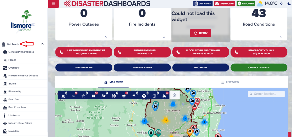
”Understanding these risks well ahead of a weather warning is important for effective disaster preparedness and response. This tab provides key information for people to help them prepare in advance of an emergency. Have a family plan. Have a grab bag of essential items ready, have insurance and important document copies handy.
”If you live in a rural or remote area that may be cut off, have extra water and non-perishable food stored, have a radio, a gas cooker (a camping cooker can go a long way) if power was down and roads were impassable.
”And remember, never cross, play or drive in floodwaters, 15cms can sweep you off your feet and 40 cms of water can move a vehicle. Flooded waters are also a health hazard as they contains harmful bacteria and contaminants.
”As part of our commitment to continuous improvement, we are currently evaluating the effectiveness of the Disaster Dashboard and exploring potential enhancements to ensure it better serves our community's needs, particularly in providing flood hazard information. Changing the icons so they align with the Australian Warning System will be part of these considerations.”
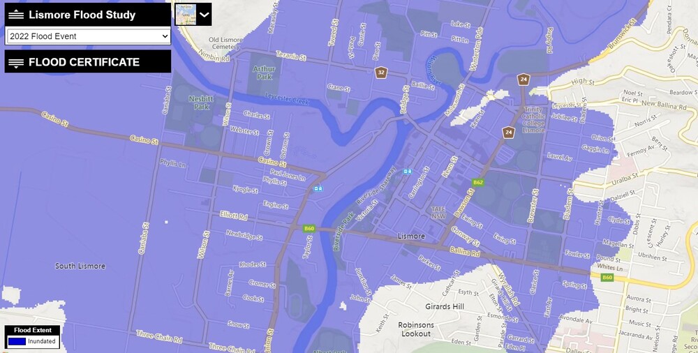
Council also provides a tool that shows Property Flood Mapping, where you can find your property on a map that shows predicted or experienced flood levels.
Does Lismore City Council have a written disaster plan to consult?
“Council's responsibilities do not entail directly creating a written disaster plan. As outlined in the legislative requirements of the State Emergency Management Plan (EMPLAN) and the State Emergency and Rescue Management Act 1989 (SERM Act), Council's primary responsibility is to support the lead Combat Agency (in this case, the SES) with resources, personnel, and equipment for emergency and recovery efforts.
“This responsibility sits with the SES, as the lead agency in any flood event. The role of Council is to assist the SES, as well as managing critical infrastructure throughout the event.
“Before a flood, council disseminates crucial information about flood hazards, preparedness, and recovery procedures. During a flood, we work closely with combat agencies and the lead agency (the SES) providing facilities, equipment, and trained staff support.
“In the event of a disaster, Council may expedite applications for emergency works and facilitate funding for recovery operations.”
How does Lismore City Council manage flood risk?
“Managing flood risk is a collective responsibility, and communities must be adequately prepared, understand how to respond to flood threats, and recover from their impacts. Councils’ role in flood risk management includes conducting studies to assess flood risk, exploring and operating mitigation options such as flood protection schemes, and sharing information with the community about flooding while supporting emergency management planning.
“Councils in NSW adhere to guidelines for developing local flood risk management plans, which typically involve:
- Conducting flood studies to estimate the hazard posed by flooding, including factors such as depth, velocity, and frequency of floods, both presently and in the future.
- Undertaking risk assessments to understand the potential impact of flooding on personal safety, property, and infrastructure.”
What weather monitoring instruments does Lismore City Council use?
“Climate data within the Northern Rivers region is sourced from various measurement stations operated by different entities.
”Ongoing efforts at both local and state levels, spurred by recommendations from the 2022 Flood Inquiry, aim to clarify responsibilities and enhance coordination. Currently the BoM own a number of gauges, with Lismore City Council owning and maintaining 15 water level stations and 14 rainfall stations across the catchment. These are inspected and maintained every three months, with the Bureau of Meteorology calibrating both its, and Councils’, rain gauges every 12 months.”
All of the information collected by these instruments are fed to the BoM to be modelled into weather predictions, that are in turn used to warn people of weather event conditions.
”During the 2022 natural disaster two rain gauges and four river gauges were damaged and stopped working when they went under the flood waters. These gauges have now been relocated to above the 2022-flood level and are fully operational.
“The Bureau of Meteorology oversees two key networks: the climate network and the flood network. The climate network comprises automatic weather stations primarily situated in major urban centres and vital infrastructures. These stations monitor variables like rainfall, temperature, and atmospheric pressure at high frequencies. While they serve environmental monitoring purposes, they may not meet the specific requirements for emergency situations.
“BoM also manages rainfall stations within the flood network, specifically tailored to support flood warning services. Despite providing real-time data, these stations often have shorter historical records. Additionally, there are other networks, including climate stations operated by Water NSW, Manly Hydraulics Laboratories, and those managed by local government authorities (LGAs) for water infrastructure management.
“However, it's important to note that these stations primarily serve other functions and are repurposed for flood warning where there is an absence of dedicated infrastructure. ”
Contacting Council during a weather event
“During a flood, the primary contact for support is the SES supported by other emergency service providers. In New South Wales, Emergency Service Providers encompass various agencies such as the Ambulance Service of NSW, Fire and Rescue NSW, NSW Police Force, NSW Rural Fire Service, and the State Emergency Service.”
Stop Press
Lismore City Council informed us that a new position is to be filled, very shortly - an Emergency Management Coordinator. Their role will include a range of duties that include liaising with people affected by emergency situations and organising feedback on emergency related events. More details to be released, shortly.
Other stories in this series includes:
Part 1: Essential Energy
Part 2: Communications - Telstra and Optus
Part 2: Communications - TPG Telecom and nbn
Part 3: Police and Fire + Rescue
Part 4: Critical Flood Information
Part 5: Animals
Part 6: Federal Government
Part 7: Charities

