Exact locations locked in for CSIRO flood mitigation modelling

Simon Mumford
11 January 2026, 6:32 PM
2026 is an important year for the Lismore LGA, with the 2022 post-flood construction phase kicking into gear on a large scale, and the final CSIRO flood mitigation report is due for release by June 30.
Of course, the CSIRO report is vitally important to other local councils, as it covers the entire Richmond River Catchment.
The Lismore App had a chat with lead scientist Jai Vaze to get an update on the flood mitigation project, the Northern Rivers Resilience Initiative (NRRI), as it is officially known.
The most important bit of information was that the exact locations for the detention basins have been identified. These will not be revealed until the completed flood modelling is released in just over five months' time.
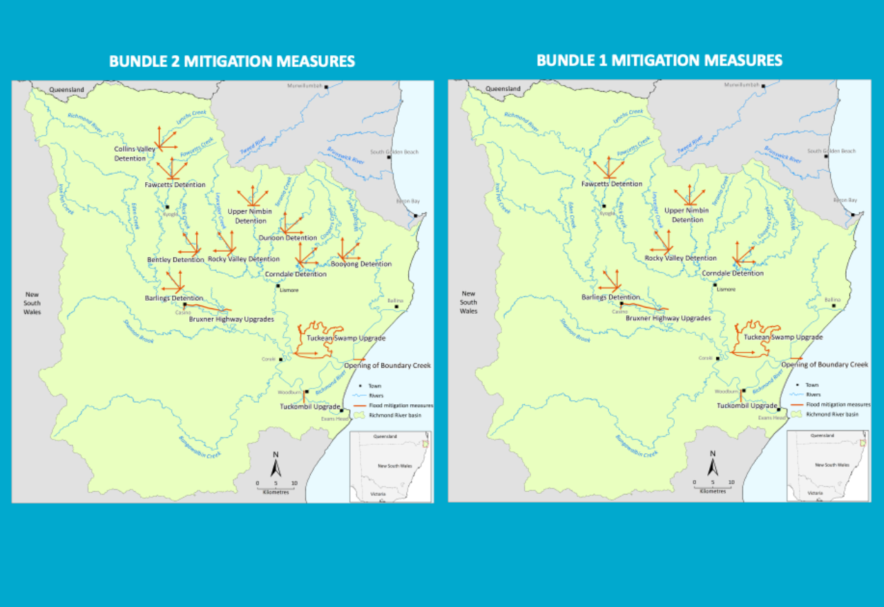
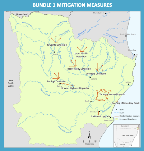
Lismore App readers would remember that following community consultations in July and August last year, Jai and his team put together two bundles to be modelled.
Each bundle will include six scenarios to be modelled. The major difference between the two bundles was the number of detention basins used to hold back water flow, with Tuckean Swamp Upgrade, Opening of Boundary Creek, Bruxner Highway Upgrades and the Tuckombil Upgrade as constants in both bundles.
Bundle One included 5 detention basins: Fawcetts Detention, Barlings Detention, Rock Valley Detention, Upper Nimbin Detention, Corndale Detention, Tuckean Swamp Upgrade, Opening of Boundary Creek, Bruxner Highway Upgrades, Tuckombil Upgrade.
Bundle Two included 9 detention basins: Fawcetts Detention, Barlings Detention, Rock Valley Detention, Upper Nimbin Detention, Corndale Detention, Tuckean Swamp Upgrade, Opening of Boundary Creek, Bruxner Highway Upgrades, Tuckombil Upgrade, Collins Valley Detention, Bentley Detention, Dunoon Detention, Booyong Detention.
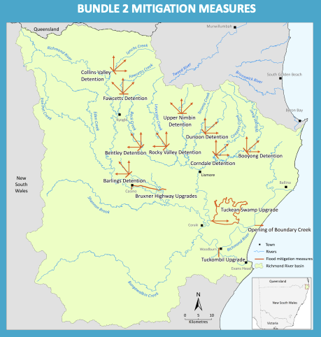
Following the community consultations, which included the seven local councils and federal and state ministers, some changes were made.
Bundle One: Barlings Detention was replaced by Eden Detention. Eden Creek is further to the northwest of Casino. The proposed Upper Nimbin Detention has been removed, and Dunoon Detention has been added (and was originally only proposed in Bundle Two).
Bundle Two: Upper Nimbin Detention has been renamed Goolmangar Detention (same location; name updated to reflect the stream rather than the town), and Eden Detention has been added.
To clarify, a detention basin or detention pond temporarily holds back water at various choke points of the catchment so it can be released at precise times during a flood event. The aim is to minimise the flood levels in Lismore and towns further down the Wilsons and along the Richmond River, so Casino, Kyogle, Coraki, and Woodburn as the water flow out to sea quicker.
"These are not permanent dams; these are detentions, which is when you need to hold water back, you hold. After the flood event peak has passed, you release that water safely, to basically empty. And after that, the river will flow normally. There will be no blockage of the river under normal conditions. It's only holding during those peak periods," Jai explained.
Another point Jai wanted to make is that this initiative is not a silver bullet for Lismore and the Northern Rivers.
"I have never promised that we will reduce it (flood levels) by x or y or z, because until we have done the modelling, we don't know. There are figures quoted by different people. I don't take responsibility for that. Neither myself, my team or CSIRO, has ever quoted a number because we don't know.
"2022 was a catastrophic event, which it has never reached before. So, 14.4 is a level that is so extreme. That's why we have picked three events to see up to what level we might be able to protect fully, and at what level, like the 2022, what's the max we can reduce. So that's what we'll be testing."
The three flood events that Jai and his team will be testing are 2022, as mentioned, 2017 and 2008, which affected Kyogle and Casino more than Lismore. In fact, Lismore never reached the major flood level.
In October 2025, the two bundles and six scenarios were approved by the Minister for Emergency Management.
"After that, in November, we started finalising the exact details and location sizes. Christmas, everything sort of shuts down. People are back now, and we are at a point where we have the locations for Bundle One and Bundle Two. So, now it will be setting that up into the model. It is a complex part. After that, we will start doing the runs. Then we will need to make sure that the implementation is correct.
As is the case with the previous reports and models, the data will be reviewed by two independent international experts to ensure it is valid, accurate and credible.
June 30 is only just over five months away, and the model is being created to make the number of runs it needs to complete the NRRI project. Is it on time?
"I will say yes and no because this is not a factory job where you just run it. The biggest aspect is when exactly to start holding the water, so that we get the maximum benefit in terms of production of peak and flooded areas, and the time it is flooded. So that will need a number of iterations, and given the massive size of the model, it will be touch and go.
"Hopefully, we will deliver on 30 June. I have delivered everything on time so far; the milestone has been delivered. So, if we can deliver this, then this project you can say that everything was delivered as promised since 2022.