CSIRO announces two bundles for Richmond River Catchment flood mitigation

Simon Mumford
28 September 2025, 8:00 PM
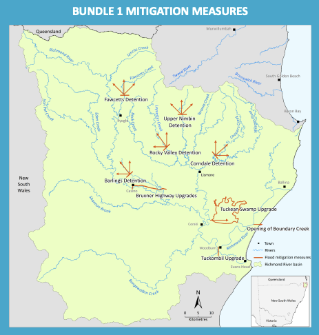
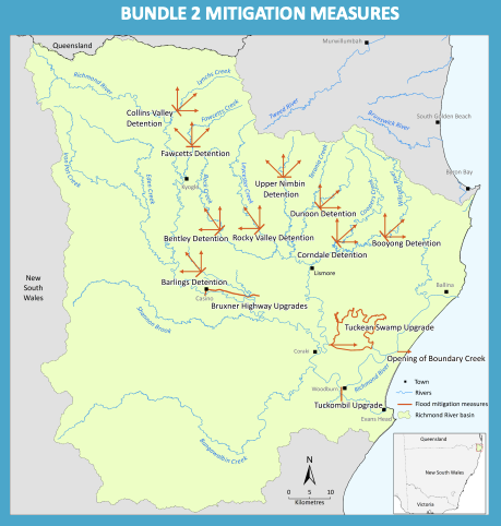
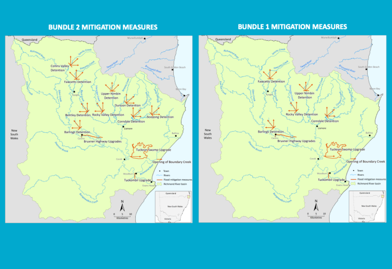 The two bundles being modelled by the CSIRO to mitigate major floods for the Richmond River Catchment
The much-anticipated Richmond River Catchment flood mitigation modelling scenarios were presented to local Council's and community groups last week by lead CSIRO scientist, Jai Vaze and his team.
After numerous community meetings and considering what makes sense from a scientific point of view, two bundles will be modelled, with the difference being the number of detention basins at choke points in the upper and lower areas of the Richmond River Catchment. Bundle 1 will model 5 detention basins, while Bundle 2 will model 9 detention basins.
The four constants are the Tuckean Swamp upgrade (barrage operates optimally), the Tuckombil upgrade (replace Fabri-dam with a swing gate), Bruxner Highway upgrades (culverts) from Casino and the opening of Boundary Creek to the ocean north of Evans Head. The Boundary Creek calculations in terms of the effective width have not been calculated yet.
Three different rainfall scenarios will be tested within those bundles: 2008, 2017 and 2022.
2008 was requested by the Kyogle and Richmond Councils as it was their worst flood since 1954. In Lismore, the river height was just under a major flood level, so a moderate flood of 9.4 metres. As we know, 2017 was 11.59 metres, while 2022 was 14.4 metres in February and 11.4 metres in March.
The two bundles of measures selected by the majority of the community and councils are:
Bundle 1. Fawcetts Detention, Barlings Detention, Rock Valley Detention, Upper Nimbin Detention, Corndale Detention, Tuckean Swamp Upgrade, Opening of Boundary Creek, Bruxner Highway Upgrades, Tuckombil Upgrade.
Bundle 2. Fawcetts Detention, Barlings Detention, Rock Valley Detention, Upper Nimbin Detention, Corndale Detention, Tuckean Swamp Upgrade, Opening of Boundary Creek, Bruxner Highway Upgrades, Tuckombil Upgrade, Collins Valley Detention, Bentley Detention, Dunoon Detention, Booyong Detention.
To clarify, a detention basin or detention pond temporarily holds back water at various parts of the catchment so it can be released at different times during a flood event. The aim is to keep the water from overtopping the levee in Lismore, thus also having an impact on towns further down the Wilsons and Richmond River, like Coraki and Woodburn. That is the same scenario for the Upper Richmond River north of Kyogle.
Jai Vaze sat down with the Lismore App on Friday to explain the options in more detail, including their size.
"In the first, less aggressive bundle in Lismore where the Wilsons breaks into two main streams, we just hold one of the two. So, we are holding at Coopers Creek at Corndale. If you look at Terania, which comes and joins Leycester before Lismore, Terania, again, splits into multiple streams, one of which is Terania Creek, which is going towards Nimbin, so we hold on the upper Nimbin area.
"Leycester Creek actually has two arms. One is the Leicester Creek itself, and one is Back Creek, which is also quite big area, so we hold one at Rock Valley Detention on Leycester Creek. So, we are holding one arm of the three, which has two or three arms.
"In the second bundle, we add three more detentions to these existing three, so that we have more holding points. And then the trick is about how to hold and when to start holding in individual detentions, because that has to be triggered based on levels, at Lismore, as the aim is to keep the water below the levee level.
"We might not be successful for say '22, but that's the aim. Looking at the water that went through Lismore in the '22 flood in one day, 500 to 700 gigalitres of water on the 28th of February went through. The largest storage in Australia is the Hume dam, which is 1000 gigalitres. So, you can't hold that in a tiny catchment up here.
"The whole idea is how to keep it below the levee. That's the whole trick. They have to be optimised such that different one starts holding at different times, thus taking off the peaks.
THE SIZE OF THE DETENTION BASINS
"Ideally speaking, they will be optimised, and based on that, the height and width will get optimised. But then, we have to do a compromise where we can't just go 10 kilometres wide and 500 metres tall. As you increase the width and you increase the height, you can hold more and more, sure, but then you will submerge more area as well. Most of these have been selected as they are at choke points. The choke point is the narrowest point where you will need the smaller barrier, and they are mostly in a deeper gorge, so that it will not submerge too much, or any of the residential areas. That is the aim.
Jai mentioned that a detention basin could serve a dual purpose, so it becomes part dam.
"This type of basin can be dual purpose, like the one in Queensland, which is, I think, I might be wrong, but 50% for water supply and 50% for flood mitigation. So normally it will only hold 50% of the capacity. When the flood comes, the gates close, and they will hold another 50%.
"After the flood, you release that so that the buffer is ready for holding the next flood. There are people who are asking questions, saying that's not doable, and I said, Yes, Queensland is already doing it. Go and see. And around the world, Japan is doing it, and others are doing it. So it's all doable. When you know the science, it's all doable."
THE GOVERNMENT'S ROLE
Jai warned that when the modelling is complete, the result may not show that flood mitigation can be achieved. He also said that when he has made his recommendations to NEMA (National Emergency Management Agency) and the Federal Government, his job is done. It will be up to the government of the day to make the ultimate decision.
"What we have been explaining is that we have been given a task, which is, can we mitigate large to extreme floods? That is the terms of reference, because the project was funded after the '22 flood, which was a disaster. So, it's not about all the other things. The focus is on whether floods can be mitigated. So, at least we'll have an answer. If nothing can be done, or something can be done.
"Number two, the outcome of this has been very clearly right from day one. The CSIRO will put out a recommendation based on the science and the results that come out from the science. After that, it is the government of the day that will be making the call. But if, in that recommendation, we find that we can't do anything, nothing has to be done anyway, but at least it's still helpful, because it's telling us to stop wasting time trying, because when we tried, using the best science, nothing can be done.
"I don't expect that will be the outcome, but we don't know the results. Whatever the outcome, the government will look at the cost-benefit ratio, plus the business cases, plus environmental approvals. Some of the options might not get through because they're too damaging to the environment. But then the government of the day has to make the call on how it balances environment, finances, community and the livelihood.
"If we do manage to find some solution which the government implements, it will improve, surely, the security for areas and help them with all the other things, like insurance and those things."
As has been mentioned during previous visits, Jai reinforced that nothing could hold back the impacts of a February 28 2022, 14.4m flood. The soil was completely saturated, so there was no further storage capacity. This modelling is really about taking a 2017 flood of 11.59m so it doesn't overtop the CBD levee wall, as well as lowering the impact downstream.
"If we can reduce the impact and then make it safer for more common products like the '17 flood, then that gives more confidence to the community and the businesses. That is the aim.
"Number two, these are infrastructure solutions, which we are putting together measures at the moment, but NEMA, through the NRRRP, has funded close to $11.8 million of nature-based solution projects in the first round. They have been running for the last two and a half years, and we are hoping that they will put out some concrete results, then we can scale to see how much they will help. If they show very clearly that it will help with floods and large floods, surely they will go hand in hand with the infrastructure solutions. There's no competition between infrastructure and nature-based. The focus is slightly different; both are needed, but they go in parallel rather than competing."
As was the case with the finished Richmond River Catchment model, the results will be peer reviewed by some of the world's top scientists.
"Of course, the results of the two projects, when they come out, will be scrutinised, checked, and reviewed by the top scientists. When you start looking at Lismore, you realise it is not a simple thing, because we don't have too much catchment area upstream of Lismore, 200 or 300 square kilometres is what we are looking at. So, if it shows that by putting trees in this much area, we can improve by X amount, then scale it up that, to get that 500 gig holding, or 300 Giga litre holding, what area is needed? Is it even possible to do? And is it possible to displace everyone? But all of that has to be done, and I'm hoping that those nature-based solutions will put out all those numbers with all those facts and proofs, and then we can implement it."
THE NEXT STEPS
Jai and his team will start to build the two bundles into the Hydrodynamic Model. This, he said, is the "hardest part". Then the computer modelling can begin for Bundle 1 and Bundle 2.
The data output will be reviewed by an internationally recognised scientist, as they did for the model itself. The comments and recommendations will be written and then released to the public on the 30th of June 2026.
So far, Jai Vaze and his dedicated, fully committed team (Cherry Mateo and Chi Nguyen) have delivered on their promised dates. The $11.4 million Northern Rivers Resilience Initiative (NRRI) has been the part of the flood recovery that residents of Lismore and the Northern Rivers can trust.
To use a horse racing term, we are in the home straight.

