Brace yourself - a cold snap is on the way

Simon Mumford
08 June 2021, 4:08 AM
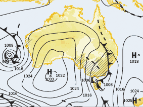
Brace yourself because the first real winter cold snap for the year is heading towards the Northern Rivers this evening.
The cold front is making its way from the west and should hit Lismore around midnight. Before the front hits, we should see some light rain increasing to showers tonight.
Melodie Sturm from the Bureau of Meteorology (BOM) said we are expecting between 5mm and 10mm of rain tomorrow before clearing Wednesday evening.
"Rain could fall as snow above 500 metres," said Melodie, "this will most likely occur in the Northern Tablelands on the western side of the ranges like Tenterfield and across the border in Stanthorpe."

If anyone is considering a drive over the ranges to look at the forecast snow, the warning for hidden patches of black ice will be present as temperatures plummet with the cold front.
Today's maximum of 21 degrees will feel balmy as we head for 17 degrees tomorrow and Thursday. The fresh westerly winds will make that feel even colder in the coming days.
There will be a coastal wind warning tomorrow as the change moves through.
If you haven't tuned on your electric blanket or put the winter doona on the bed, now might be the appropriate time as minimum temperatures are forecast to drop to 3 or 4 degrees. The cold mornings should remain with us into the weekend while the daily temperatures slowly rise to 18 on Friday, 19 on Saturday and a more normal 20 degrees on Sunday.
SHOP LOCAL
