BOM predicting wetter than average spring
Simon Mumford
26 August 2022, 8:02 PM
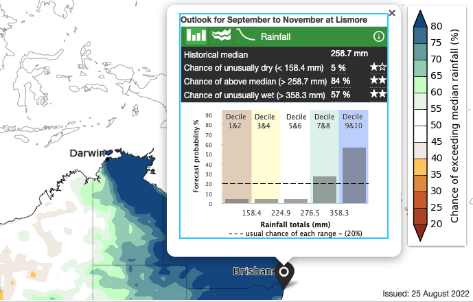
 The chance of above median for September to November. Image: BOM
The Bureau of Meteorology is expecting a wet spring for most of the eastern half of Australia where there is a high chance of above average rainfall.
The Spring 2022 Climate and Water Outlook, released on Thursday, reflects several climate influences including a negative Indian Ocean Dipole event to the west and the chance of a La Niña returning this spring increasing to around 70 per cent.
Bureau of Meteorology senior climatologist Dr Lynette Bettio said, "where soils and catchments are wet, and streamflows are high, further rainfall this spring will increase the risk of flooding for eastern Australia."
"In northern Australia, the first rains of the wet season are likely be earlier than normal for much of Queensland and the Northern Territory."
October is the official beginning of the wet season across northern Australia.
Further, Dr Bettio said a positive Southern Annular Mode (SAM) is also likely, which pushes weather systems south, bringing wetter easterly winds to NSW and fewer cold fronts to western Tasmania.
The average rainfall for Lismore at the airport over the spring period is:
- September 37.6mm
- October 88.4mm
- November 95mm
The BOM has forecast the chance of exceeding the median rainfall at 84% and the chance of an unusually wet spring (greater than 358.3mm) is 57%.

In a similar pattern to last spring and summer, we are looking at cooler maximum temperatures with an 82% chance of being under unusually low temperatures of 24.9 degrees.
For those that like a little more detail, this is the summary from the BOM.
The climate outlook reflects several significant climate influences. These include:
- A 70% chance of La Niña reforming later in 2022, with the ENSO Outlook currently at La Niña ALERT. Four of the seven models are suggesting La Niña thresholds are likely to be met by early to mid-spring.
- A negative Indian Ocean Dipole (IOD) event, which is currently under way. Outlooks indicate the negative IOD is likely to persist throughout spring. A persistent negative IOD phase increases the chance of above average spring rainfall for much of Australia. It also increases the chances of warmer days and nights for northern Australia.
- The Southern Annular Mode (SAM) index, which is currently strongly positive, and is expected to remain mostly positive throughout spring. Positive SAM has a drying influence for parts of south-west and south-east Australia at this time of year, but increases the likelihood of rainfall in eastern New South Wales, far eastern Victoria, and parts of southern Queensland.
- Sea surface temperatures, which are currently warmer than average over the Maritime Continent and around much of Australia. This pattern is likely to be contributing to the wetter outlooks.
- Australia's temperature and rainfall variability are also influenced by global warming caused anthropogenic influences (human activities). Australia's climate has warmed by around 1.47 °C in the period between 1910 and 2020, leading to increased frequency of extreme heat events, reduction in cool season (April–October) rainfall in southern Australia (10 to 20%) in recent decades, and increased proportion of rainfall from high intensity, short duration rainfall events, particularly across northern Australia.
The Bureau's climate model uses the physics of our atmosphere, oceans, ice, and land surface combined with millions of observations from satellites and on land and sea. As a result, it incorporates the influence of climate change and natural climate drivers like ENSO, IOD, the MJO, and SAM in its outlooks.
FARMING/AG
