BOM issues Initial Flood Watch for Wilsons River
Simon Mumford
09 August 2024, 8:11 AM

The Bureau of Meteorology has issued an initial flood watch for the Wilsons River from early next week.
Isolated minor flooding is possible due to a coastal trough that is forecast to develop along the New South Wales coast during the weekend and into early next week.
Showers and potentially heavy rainfall is forecast which may result in river level rises along the Northern Rivers and Mid North Coast from late Sunday and into next week.
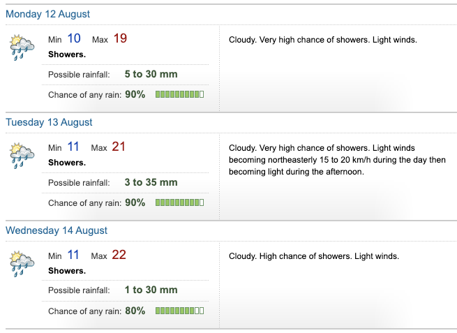
The Lismore forecast rainfall is not clear and has changed a lot in the past two days. At the time of writing (6:16pm Friday, August 9), 5-30mm is forecast for Monday, 3 to 35mm for Tuesday and 1 to 30mm on Wednesday. Earlier on Friday the top range was 40 and 45mm.

The Bureau says that catchments in the flood watch are relatively wet.
"Persistent moderate rainfall is forecast from Sunday into next week, with isolated heavier falls possible in the Northern Rivers and Mid North Coast. Localised river level rises and flash flooding are likely within the areas of heaviest rainfall, with isolated minor riverine flooding possible.
"This is a very dynamic situation, with high levels of uncertainty in the timing and location of the heaviest falls. The Bureau is continuing to monitor the situation and will provide updated advice as required. Catchment-specific warnings will be issued if and when required.
"Flood Classes (minor, moderate, major) are only defined for catchments where the Bureau provides a flood warning service.
Catchments likely to be affected include:
Wilsons River
minor flooding
Orara River
minor flooding
Bellinger and Kalang Rivers
minor flooding
For the latest flood and weather warnings see www.bom.gov.au/nsw/warnings/.
For the latest rainfall and weather forecasts see www.bom.gov.au/australia/meteye/.
For the latest rainfall and river level information see www.bom.gov.au/nsw/flood.
You can also use the Lismore App Weather & Travel button, which links to the BOM's website.
PUBS AND CLUBS

