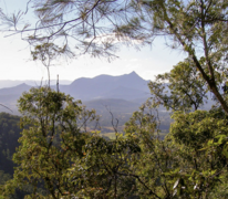
This is a Grade 4 walk. It's suitable for experienced bushwalkers with strong navigation skills.
You need to be fit and prepared for long, sometimes challenging hikes over 4 days, walking 4 to 9 hours daily with all your camping gear.
The track features steep sections, many steps, and an elevation gain of about 600m on day 2, reaching 800m.
Due to the terrain and length of this walk, you may encounter tree fall across the track that requires you to deviate off-track temporarily.
This subtropical climate can be very humid, with creek crossings that may become slippery or deeper during rainfall.
Group bookings
Book up to 2 campsites online. For larger groups, make a group booking enquiry.
Price and inclusions
From $173 per campsite. You can fit 1 medium hiker's tent or 2 small hiker's tents on the tent platform.
Includes 3 nights camping on a private hardwood tent platform and shared shelter, seating areas and toilets. Optional transfers available at extra cost. You must bring and carry your tent, food and all your own gear.
Transfers
Take the hassle out of getting there and book a return transfer with Vision Walks Eco Tours. Transfers are available from multiple locations. Prices start from $66 depending on your pickup and drop-off location. Visit the Vision Walks Eco Tours website to book or for more information.
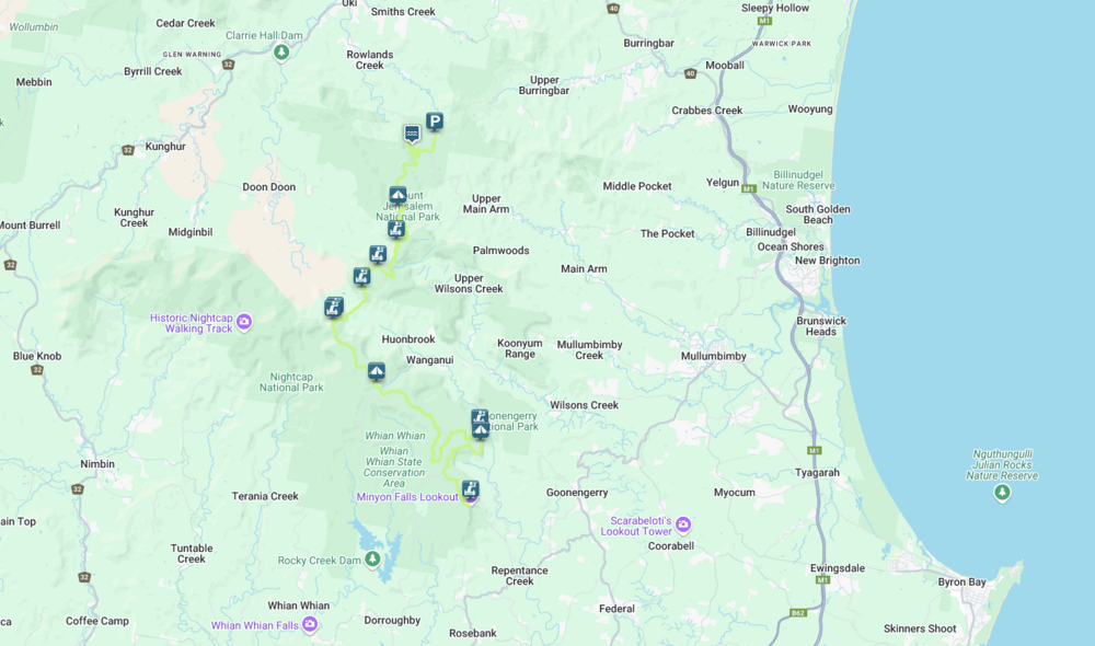
Getting there, parking and road access
If you choose not to book return transfers with Vision Walks Eco Tours, we strongly recommend you get dropped at Manns Road track head. We don't advise leaving your vehicle in this very remote location overnight. You will also need to arrange a pickup at Minyon Falls carpark at the end of the walk. The access roads may become impassable in wet weather, so plan accordingly.
From Mullumbimby, follow Main Arm Road to the end and then turn right onto Manns Road. After 2km, the Manns Road track head carpark will be on the right. From Uki, follow Manns Road for 3.5km and the carpark will be on the left. This is the same carpark used to access Unicorn Falls walking track.
What to bring
This is a 4-day self-guided walk, so you'll need to carry a waterproof backpack with a capacity of 50 litres and a dry bag. Pack enough food for 4 days and 3 nights, a fuel stove, tent, all your own camping equipment, wet weather gear and safety supplies. Bring guy ropes to attach your tent to the hardwood tent platforms.
Make sure you have containers to carry at least 5L of water. Water is available to fill up at all 3 campgrounds but it's tank water so you must treat it before drinking. Always boil water for at least 5mins before drinking or use treatment tablets, a filter or UV treatment.
Safety
This is a remote walk. The weather is unpredictable and prone to storms and flooding. Be mindful of fire season risks and be equipped for changing conditions. The track includes steep sections and several creek crossings, some with narrow boardwalks or stepping stones which can become slippery when wet. During periods of high rainfall, be prepared for shallow creek crossings.
There are narrow cliff edges along this walk. Take extra care and watch out for falling tree branches, especially after wind or rain. High wind events can occur frequently – check above camping platforms for fallen or damaged tree limbs.
In a severe storm, seek refuge under a hard roof, or low-lying, open areas. Avoid exposed locations, ridges, gorges, large trees, high points, and water edges. Delay pitching tents until storms pass.
Ticks and leeches are common in this subtropical landscape, especially in summer. Wear long, loose clothing to prevent insect bites and know how to treat a snake bite or tick bite.
Mobile phone reception is intermittent. When you don't need it, turn off your mobile or put it on airplane mode to conserve battery and take a portable power bank. Download the Emergency Plus app and consider taking a personal locator beacon for emergencies.
Check our bushwalking safety tips to make sure you pack all the essentials and are wearing the right gear.
Trip intention form
It's a good idea to let someone know where you're going. Fill in a trip intention form to send important details about your trip to your emergency contact.
Maps
Download the NSW National Parks app before you leave home, and make sure you download Nightcap National Park and Mount Jerusalem National Park in the app. This will show you where you are on a map of the walk, even when you have no mobile reception. Consider taking a portable charger for your phone. You can also print and take a PDF map of the walk with you.